A Doctrine Forged by Unmapped Waters
In the decades after the War of 1812, the United States confronted a vast and dangerous frontier not on land, but along its own shores. The nation's expanding maritime commerce, its economic lifeblood, navigated a treacherous gauntlet of unmapped shoals, shifting sandbars, and rock-strewn passages. The formal government response, the Survey of the Coast, initiated by President Thomas Jefferson in 1807, remained a theoretical solution for years. Its first superintendent, Ferdinand Hassler, was a brilliant geodesist but a poor politician. His project was starved by congressional infighting and inconsistent funding, failing to produce its first comprehensive chart until the mid 1830s. This created a critical national security and economic vacuum. While the nation pushed west, its ships were sailing blind.
Into this void sailed the cutters of the U.S. Revenue-Marine, the direct precursor to the modern Coast Guard. Chartered by Alexander Hamilton to enforce customs tariffs, these vessels were the federal government's primary maritime law enforcement agency. Their crews were seamen and federal officers, tasked with interdicting smugglers and aiding vessels in distress. They were not trained cartographers. Yet, driven by a pragmatic mandate from the Treasury Department, Revenue Cutters began undertaking hydrographic surveys. This was not a planned expansion of their mission. It was a field expedient response to an urgent national need. If the official surveyors could not map the waters, the men who patrolled them daily would have to do it themselves. This ad hoc directive marked the beginning of a dual mission doctrine, forcing the service to integrate the rudimentary science of hydrography with the harsh realities of law enforcement at sea.
The Great Lakes Proving Ground
By the 1840s, American commerce surged into the Great Lakes, a chain of inland seas whose navigational hazards rivaled any ocean. Unmarked reefs, unpredictable gales, and a near total lack of reliable charts made every voyage a gamble. The Treasury Department, under the guidance of Captain Alexander V. Fraser, the forward thinking chief of the new Revenue Marine Bureau, sought a practical solution. Fraser dispatched one of the service's newest assets, the iron hulled, side wheel steam cutter USRC Washington, to Lake Erie. The vessel, a 160 ton ship built by the West Point Foundry, represented a leap in technology. Its deployment was a direct test of Fraser's vision for a modernized, professionalized fleet capable of tackling complex challenges.
The Washington’s orders were twofold. It was to conduct its primary duty of customs enforcement, preventing the flow of untaxed goods from Canada. Simultaneously, it was to execute detailed surveys of critical harbors and shipping lanes between Buffalo and Cleveland. This forced the cutter's crew to operate in two completely different modes. One day they were a police vessel, firing a shot across the bow of a suspect schooner. The next, they were a scientific platform, methodically drifting while the leadsman took soundings. This work was arduous and entirely manual, a stark contrast to the cutter's steam powered propulsion. The data they produced, charting newly discovered shoals and documenting the shifting channels near river mouths, was not for some distant archive. It was immediately distributed to commercial captains and maritime insurers, directly impacting the safety and viability of Great Lakes trade. The Washington's successful tour proved that a single, disciplined cutter crew could effectively perform both missions, validating the emerging doctrine.
Confronting the Shifting Gulf
The hydrographic challenges of the Gulf Coast and the southern Atlantic were different in character but no less deadly. Here, the primary enemy was not static rock but the dynamic, ever changing seafloor of sand and silt. The Mississippi River's delta and the barrier islands of the Carolinas were in a constant state of flux. Channels and sandbars could shift dramatically after a single tropical storm, rendering a year old chart a lethal deception. In the 1850s, the duty of charting these treacherous waters fell to vessels like the USRC Jefferson. Originally built as an experimental steam cutter with a flawed Hunter's Wheel propulsion system, the Jefferson was too slow for effective pursuit duties. Its mechanical liabilities, however, made it a suitable candidate for the slow, methodical work of surveying. It was transferred to the U.S. Coast Survey in 1848, often crewed by Revenue-Marine officers.
Under the command of skilled officers like Lieutenant Thornton A. Jenkins, a man who would later become a Rear Admiral, the Jefferson's crew took on some of the most dangerous waters, including the infamous Hatteras Shoals. During a survey of the Carolina coast in July 1849, the crew's dual identity was put on sharp display. They paused their painstaking hydrographic work to rescue the crew of the dismasted brig Benjamin Carver, which was drifting helplessly toward the shoals in the aftermath of a gale. They secured a line to the stricken vessel and towed it to safety. This incident perfectly captured the operational reality for cutter crews. The Jefferson's survey work involved the same laborious process of lead line soundings and sextant fixes, but in an environment where the very ground beneath the keel was unstable. This demanding operational tempo, blending law enforcement, search and rescue, and scientific measurement, forged a unique professional identity. Cutter crews had to be masters of both the sextant and the ship's 6 pounder cannon.
The Doctrine of Lead Line and Sextant
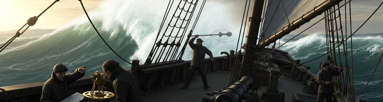
The men serving on these cutters were not specialist hydrographers on loan from a scientific body. They were federal law enforcement officers and professional sailors. Their core function was boarding vessels, inspecting cargo manifests, and, if required, chasing down and seizing smugglers. The hydrographic mission was an additional, complex layer of responsibility executed with rudimentary tools that demanded immense practical skill. Aboard a small cutter rolling in an offshore swell, taking an accurate sounding was an art. The leadsman would stand in the chains, a small platform outside the ship's rail, and swing a seven or fourteen pound lead weight. He would cast it forward, allowing it to hit the bottom as the ship passed over it, calling out the depth from the colored markers on the rope. The bottom of the lead was armed with tallow to bring up a sample of the seabed, sand, mud, or shell, which was just as important as the depth itself.
Fixing the ship's position was an even greater challenge. It required at least two officers on deck with sextants, often bracing against the ship's motion. They would simultaneously measure the horizontal angles between three known points ashore, such as a lighthouse, a church steeple, and a prominent headland. A third officer would record the time and measurements, which were then used to plot the ship's position on a chart using a three armed protractor. All this took place on the same deck that might have just been cleared for action or used to bring aboard the survivors of a wreck. The ship's chronometers, the delicate, expensive clocks essential for determining longitude, had to be protected from the constant vibration and shock of a working vessel that might be pounding through heavy seas in pursuit of a smuggler.
This operational duality created a doctrine of extreme adaptability. The Revenue-Marine officer had to be a polymath, a capable ship handler, a firm customs official, a competent navigator, and a precise surveyor. The cutters themselves were material compromises, armed for enforcement but also carrying the specialized tools for charting. The hard won experience aboard vessels like the Washington and Jefferson proved that a maritime force could effectively perform both constabulary and scientific duties. The ad hoc necessity of the 1830s had, by the 1850s, solidified into a core component of the Revenue Cutter Service's identity, laying the doctrinal groundwork for the multi mission service it would become.