
The Mandate for National Improvement
The War of 1812 exposed the United States' raw vulnerability. British coastal raids and failed campaigns into Canada highlighted a crippling lack of strategic infrastructure. Moving troops and supplies across the young republic proved a monumental task, often doomed by impassable roads and unnavigable waterways. In the war’s aftermath, national leaders like Secretary of War John C. Calhoun recognized that internal security and economic vitality were intertwined. This realization, born from near-disaster, set the stage for an unprecedented expansion of federal power, executed not by politicians in Washington, but by a small cadre of uniformed engineers in the wilderness.
Congress acted. On April 30, 1824, it passed the General Survey Act, a landmark piece of legislation that formally weaponized infrastructure for national development. The act authorized President James Monroe to employ Army engineers to survey routes for roads and canals deemed of national importance for commercial or military purposes. This was not merely a suggestion. It was a directive that fundamentally altered the mission of the United States Army Corps of Engineers. Previously focused on coastal fortifications, the Corps was now tasked with binding the nation together with transportation arteries. The initial appropriation was a modest $30,000, but it opened the floodgates for a new era of federal involvement in internal improvements, overcoming fierce constitutional debates about states' rights and federal overreach.
To execute this broad mandate, the War Department established the Board of Engineers for Internal Improvements on May 31, 1824. This body, led by the influential Napoleonic-era engineer General Simon Bernard, became the central nervous system for a nationwide survey program. Bernard, an émigré who had served as an aide-de-camp to Napoleon, brought a professional, scientific rigor to the task, a standard that American counterparts like Colonel Joseph G. Totten eagerly adopted. Their reports were not simple sketches. They were detailed analyses of topography, resource availability, and construction cost estimates. Projects undertaken under the Act’s authority were vast and ambitious. Army engineers laid out the definitive path for the National Road, a vital artery pushing west from Cumberland, Maryland. They conducted exhaustive surveys for the Chesapeake and Ohio Canal, a massive project intended to link the Potomac River with the Ohio River Valley. Other survey parties fanned out across the country, examining potential canal routes to connect the Great Lakes, bypass the treacherous Muscle Shoals on the Tennessee River, and chart a road from Detroit to Chicago.
The scope was breathtaking. By the late 1820s, dozens of Army engineers were detailed to survey projects across multiple states. They plotted a road connecting Little Rock, Arkansas, with Memphis, Tennessee, and surveyed the James River and Kanawha Canal route in Virginia. These were not yet construction projects, but the detailed surveys, plans, and estimates produced by the Corps provided the essential groundwork for federal, state, and private investment. The General Survey Act effectively made the Army Corps of Engineers the nation’s primary source of engineering expertise, setting a precedent for its dual military and civil works mission that persists to this day.
Logistics in the Unmapped Interior
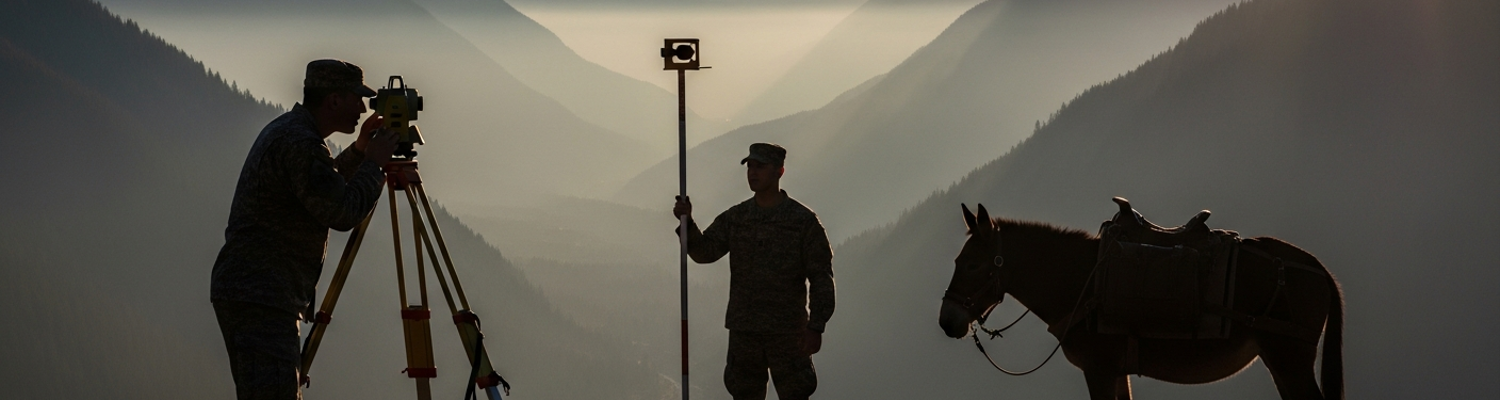
The legislative clarity of Washington D.C. dissolved into the harsh realities of the American frontier. For the small survey parties dispatched by the Board of Engineers, the wilderness was an unforgiving operational theater. A typical unit consisted of a junior officer fresh from the United States Military Academy at West Point, a handful of enlisted soldiers, and a larger group of civilian hires: axemen, chain carriers, and teamsters. These teams operated for months at a time, hundreds of miles from the nearest military post, in territory that was often unmapped and contested. Their delicate and expensive survey instruments, such as theodolites for measuring angles and Gunter's chains for distances, required careful handling on pack mules over brutal terrain.
The logistical challenges were immense. Sustaining these remote detachments became a constant struggle. Provisions were a primary concern. The Army, having learned hard lessons during the War of 1812, was reforming its supply systems, but these were still geared towards larger formations at fixed garrisons. Survey parties relied heavily on a system of ad-hoc civilian contracts. Local contractors were engaged to provide everything from salt pork and hardtack to fodder for pack animals. This system was notoriously unreliable. Supplies often arrived late, were of poor quality, or failed to arrive at all. A broken wagon axle or a lame horse hundreds of miles from any settlement could force a party to suspend operations and subsist on what they could hunt.
Security was another constant threat. Survey teams were the vanguard of westward expansion, and their presence was often viewed with hostility by Native American tribes whose lands they traversed. While major conflicts were rare for these small units, the threat of attack was always present. To mitigate this, survey expeditions often coordinated with or were protected by detachments of local militia. The greater dangers were often more mundane. Disease, from malaria and yellow fever in the southern swamps to dysentery from contaminated water, disabled entire parties. Officers administered quinine as a prophylactic, but it was an imperfect defense. Accidents, a constant risk when felling trees to clear sight lines, navigating rapids in canoes, or handling black powder for rock blasting, took a steady toll. The physical environment itself was the most relentless adversary. Engineers and their men endured brutal summer heat, autumn floods, and winter blizzards, all while performing the physically demanding work of cutting paths through dense forests and dragging survey chains across miles of rugged terrain.
The solutions to these problems were born of necessity and innovation. Officers learned to be ruthless logisticians, planning supply caches months in advance and establishing multiple redundant routes. They became adept at field diplomacy, negotiating passage with local tribes or leveraging the protection of frontier settlements. The daily grind of building their own shelters, repairing their own equipment, and finding their own food forged a culture of extreme self-reliance. The pristine theories of engineering learned at West Point were tested and tempered in the crucible of the frontier, creating a new type of military officer who was as much an explorer and logistician as he was an engineer.
Doctrine Forged in the Field
The decades of civil works projects between the War of 1812 and the Mexican-American War were not a diversion from the Army’s military purpose. They were, in fact, a period of intense and practical doctrinal development. The experience gained in building the nation’s infrastructure directly shaped the Army’s ability to wage war and project power across the continent. This period of nation-building provided the geographic knowledge, transportation routes, and expeditionary mindset that proved decisive in future conflicts.
The most immediate benefit was the creation of a vast repository of geospatial intelligence. The maps and surveys produced by the Corps of Engineers and the separate Corps of Topographical Engineers (established in 1831) were the most accurate and detailed of their time. These were not mere commercial charts. They were military-grade documents detailing terrain, obstacles, resources, and transportation routes. This knowledge was invaluable. During the Second Seminole War in the 1830s, Army engineers who had previously surveyed Florida for canals and roads were recalled to guide columns through the territory’s treacherous swamps. In the Mexican-American War, maps created during earlier boundary and exploration surveys informed General Winfield Scott’s brilliant campaign from Veracruz to Mexico City. The detailed reconnaissance performed by his engineer officers, including Captain Robert E. Lee, allowed Scott to bypass fortified positions and consistently outmaneuver his opponents.
The infrastructure itself became a strategic asset. The National Road, built and surveyed in large part by Army engineers, facilitated the rapid movement of men and materiel westward. The harbor improvements on the Great Lakes and the Atlantic coast, designed and supervised by the Corps, supported naval logistics and commercial shipping alike. These routes, conceived for commerce and mail, became the logistical backbone for military campaigns, allowing the Army to sustain forces farther from its industrial base than ever before. The experience of building these projects, often with limited resources and in austere environments, became a core competency of the engineer officer. Robert E. Lee’s early career work designing a system of dikes and jetties to alter the course of the Mississippi River at St. Louis demonstrated this on a grand scale.
This practical experience flowed directly back into military doctrine and education. The curriculum at West Point, already heavily focused on civil and military engineering under Superintendent Sylvanus Thayer, was continuously updated with lessons learned from the field. Officers returning from survey duty often served as instructors, bringing a gritty realism to the theoretical education of cadets. They taught not just how to design a bridge, but how to build one with green timber under duress. They taught not just how to calculate the volume of earth to be moved for a canal, but how to manage a mixed workforce of soldiers and unruly civilian contractors to get the job done. This created a generation of officers who understood logistics, topography, and project management at a fundamental level. Graduates like George G. Meade, Joseph E. Johnston, and P.G.T. Beauregard all began their distinguished careers on these peacetime engineering projects, experience that would profoundly shape their generalship in the Civil War.
Enduring Lessons for Modern Warfare
The work of these early frontier engineers provides a powerful historical analogue for contemporary military challenges. The fundamental problems of projecting power, managing complex logistics, and leveraging infrastructure for strategic advantage remain constant. The 19th-century survey party, reliant on unreliable civilian contracts for sustenance, is the direct ancestor of today’s forward operating bases supported by massive LOGCAP (Logistics Civil Augmentation Program) agreements. The challenge of a broken wagon wheel in 1830s Arkansas is functionally identical to a disabled MRAP waiting on a contractor-sourced part in 21st-century Afghanistan. Both scenarios highlight the persistent friction between military necessity and logistical reality.
The dual-use nature of the infrastructure built by the Corps established a paradigm of military-supported stability operations. The roads and canals that fostered economic growth and national unity in the 1820s are an early example of using infrastructure development as an instrument of national power. This concept is alive today in efforts to build roads, schools, and power plants in post-conflict zones as a means of winning local support and creating stable security environments. The U.S. Army Corps of Engineers' mission in modern Iraq, restoring electrical grids and water treatment plants, is a direct continuation of this legacy.
The period underscores the timeless importance of owning the geospatial and logistical terrain. The meticulous mapping of the American interior by the Corps of Topographical Engineers provided a decisive strategic advantage. Today, this mission has evolved into the sophisticated work of the National Geospatial-Intelligence Agency, but the core principle remains the same. A superior understanding of the operational environment is a prerequisite for victory. The 19th-century engineer’s transit and chain have been replaced by satellites and drones, but the mission of mapping the battlespace, both physical and human, is unchanged.
The era of the frontier builder solidified the U.S. Army Corps of Engineers' unique identity. It proved that military engineering could be a powerful tool for both national defense and national development. The lessons learned clearing forests for the National Road and blasting rock for the C&O Canal forged a doctrine of adaptability, improvisation, and large-scale project management that became the hallmark of the Corps. This foundational experience, gained in the service of building a nation, created an engineering force capable of supporting an army across a continent and, eventually, around the world.