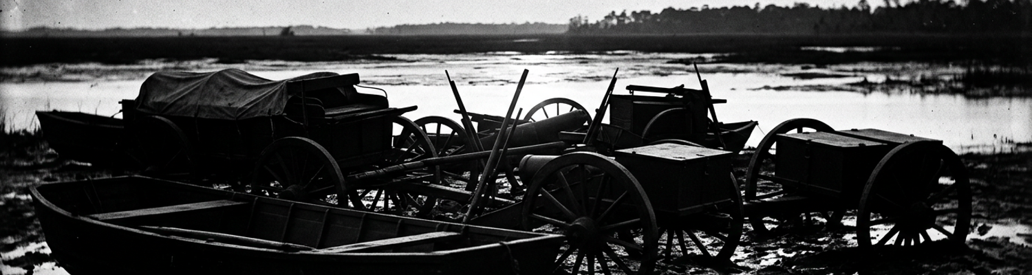

Post-Action Gathering on the Bon Secour Estuary
The brackish marsh along the lower Bon Secour River sat motionless. Riders in blue wool held their reins tight against lathered horse necks. Coastal wind moved through the loblolly pines. Salt-laden water lapped against the black tidal mud.
A single gunshot tore through the scrub oak.
Four hours later, the firing died away into a gray drizzle. Archival evidence shows staff officers under Brigadier General Thomas J. Lucas immediately began collecting wet field dispatches. These couriers rode hard from the coastal approach routes near Weeks Bay. Pencils cut through rain-soaked order paper. Aides recorded erratic clashes with Confederate defenders. Detached companies from the 15th Confederate Cavalry and local Alabama home guard units contested every sandy ridge between the river bend and the shoreline. These defenders used dense gallberry thickets to conceal quick shotgun blasts. They retreated into unmapped cypress bottoms.
Every bypass ended in an impassable swamp.
When examining the historical record of the coastal approach during the Mobile Campaign, Lucas's cavalry scouts pulled up their trembling mounts along the rain-soaked banks. These men were drawn primarily from the 2nd New York Veteran Cavalry and the 31st Massachusetts Mounted Infantry (NARA Record Group 393). Accompanying pioneer units and engineering details stood waist-deep in coastal silt. They wrestled with fractured pontoon timbers and overturned baggage carts. Heavy timber balks intended to bridge the marshy runoffs cracked under the passage of three-inch ordnance rifles. Wagon tongues snapped under sudden lateral shifts in the mud. Iron link-pins tore free from wooden axletrees. Supply caissons dropped straight into soft alluvial mire.
Exhausted draught animals collapsed directly into the muck.
Lucas dismounted near an abandoned oyster-shell landing to inspect the physical wreckage. Pioneer sergeants used iron-tipped handspikes to lever swollen pine stringers. Mounted scouts held an uneasy picket line along the swamp margins. A close review of operational logs indicates that hastily compiled dispatches revealed deep command confusion across the coastal approaches. Scout reports flooding the estuary command post described rebel marksmen using heavy English Enfields to target draft teams. They deliberately disabled wagons at blind turns in the pine scrub. Thirty-eight cavalry mounts were registered as dead or disabled from severe puncture wounds. These wounds were caused by fire-hardened pine stakes planted beneath the tidewater crossings.
Couriers sent south to establish visual signaling with Union naval gunboats failed to make contact through the low coastal fog.
Their animals foundered in deep sand drifts near the beach. Lucas's brigade quartermaster logged an immediate loss of three thousand rounds of rimfire ammunition ruined by saltwater. Two pioneer tool wagons were abandoned past recovery in the Bon Secour silt.
Lucas's Cavalry Sweeps and Civil Evacuations
The blue-coated cavalry did not pause to bury dead horses before pressing north.
When examining the historical record of the eastern coastal build-up, Brigadier General Thomas J. Lucas held explicit orders to deploy his entire cavalry brigade across the sandy expanses immediately east of Bon Secour Bay. His specific operational assignment was to erect an impassable mounted shield covering the exposed right flank of Major General E.R.S. Canby's troop concentration at Mobile Point. Canby needed uninterrupted time to assemble nearly forty-five thousand men from the XIII and XVI Army Corps. Artillery pieces and transport vessels arrived along the Gulf shores. Lucas threw out forward screening detachments consisting of the 2nd New York Veteran Cavalry, the 1st Louisiana Cavalry, and mounted elements of the 31st Massachusetts.
These riders pushed hard through the pine barrens toward Fish River.
They fanned out across unpaved cart tracks and established static outposts at every marsh crossing. By physically occupying the sand ridges between Bon Secour and the interior waterways, Lucas blinded Confederate observers under Colonel Harry Maury. Rebel scout patrols failed to discover the precise landing beaches chosen for Canby's amphibious staging. Troopers maintained forty-eight-hour saddle watches. They slept with reins wrapped around their forearms. Relay riders galloped back to beachhead telegraph terminals with reports of enemy troop concentrations along the Tensaw line.
Cavalry hooves churned the dry coastal sand into powder.
Archival evidence shows that Federal flanking columns triggered an immediate flight among the civilian population of southern Baldwin County. The sudden appearance of Lucas's scouts along the Bon Secour waterways convinced rural families and local salt workers that a scorched-earth campaign was under way. Hundreds of noncombatants abandoned their homesteads within hours. They loaded wagons with whatever bacon, cornmeal, and bedding could be dragged from storehouses. Farm families hitched milk cows to heavy farm carts alongside underfed mules. This blocked the narrow backwoods roads leading north toward Stockton and the Alabama interior.
Turpentine camps and small salt-boiling operations along Weeks Bay sat deserted.
Their iron evaporating kettles were cold. Their timber vats were left standing wide open. Federal advance guards found smokehouse doors swung wide. Domestic dogs barked at empty verandas. Untended field crops were trampled by livestock turned loose to avoid capture. Wealthier coastal residents fled inland toward Montgomery or Cahaba aboard overloaded buggies. They abandoned iron strongboxes, heavy furnishings, and winter provisions directly in the roadside sand when draft axles cracked under the weight.
Unattended pine fires spread across the empty plantations.
A close review of operational logs indicates that this rapid civilian evacuation complicated Federal movement almost as severely as Confederate resistance. Advancing squadrons encountered deep road ruts left by hundreds of overloaded refugee carts. These ruts ground the fragile sand-clay crust into deep sand beds that stalled Canby's secondary supply elements. Lucas detailed two companies of the 2nd Illinois Cavalry to herd abandoned cattle off the military approach lines. They cleared broken civilian wagons out of the single-lane corduroy passes. Pioneer platoons trailing behind the cavalry sweeps spent whole afternoons filling deep drainage ditches. Fleeing locals had dug these ditches across the road beds to prevent Union gun carriages from passing. By nightfall, cavalry patrols had gathered forty-two discarded flatboats along the river landings. Each craft was stripped of oars and scuttled with axe blows through the floor planking.
Coastal Marl Saturation and Pontoon Wagon Immobilization
Water dissolved the military roadbed within ninety minutes of the squall.
When examining the historical record of the movement through lower Baldwin County, meteorological dispatches recorded three consecutive days of violent maritime squalls driving inland from the Gulf of Mexico between March 18 and March 20. The storm front unleashed sustained sheets of rain directly over the coastal approaches running north from Bon Secour toward Danley's Ferry. Geologically, the low coastal terrain consisted of an unstable upper stratum of loose silica sand. This sat atop a dense layer of alkaline coastal marl, marine shell deposits, and saturated gray clay. Continuous downpours liquefied this subsoil within hours.
Hooves from Lucas's cavalry vanguard sheared through the thin upper crust of pine needles.
The iron tires of forward scout wagons rapidly churned the underlying marl into a dense adhesive slurry. This slurry possessed zero bearing strength. Walking infantry detachments sank past their knees into gray muck. This mud exerted severe hydrostatic suction against leather boots. Drainage ditches cut by pioneer parties failed immediately as sandy embankments sloughed inward under the water volume. Sheets of brown runoff funneled directly into the center of the cart roads. By noon on March 19, the main supply track tracing the eastern edge of Weeks Bay had disintegrated into an impassable trench of liquid soil forty feet wide.
Draught teams foundered where they stood.
Archival evidence shows that the XIII Army Corps pontoon train sustained total mechanical paralysis before reaching the Fish River turnoff. This train trailed the mounted advance along the coastal marsh margins. Each standard engineer wagon carried heavy wooden boat frames and bridging balks weighing over two thousand pounds. These were supported by narrow four-inch iron-tired wheels that concentrated extreme pressure per square inch. When these heavy engineer transports entered the saturated marl flats south of Magnolia Springs, the wheels sliced down to the wheel hubs. Wagon boxes settled until the square hickory axle-trees and kingbolts rested flat against the mud.
Teamsters lashed eight-mule draft teams to extricate individual boat carriages.
They snapped wrought-iron whiffletrees. They ripped trace chains from their harness rings. Wooden tongue assemblies splintered under the deadweight resistance. Behind the pontoon units, accompanying ammunition caissons loaded with three-inch ordnance rifle shells and twelve-pounder canister shot encountered identical entrapment. Wheels sank past the linchpins into the black muck. Artillerymen attempted to lever the carriages using five-inch white oak handspikes. The soft marl offered no solid fulcrum. Pine fence rails shoved beneath the sunken hubs sank directly into the saturated ground. They drove vertically into the subterranean quicksand without lifting the load.
Every sudden lurch broke more harness leather.
A close review of operational logs indicates that engineer officers halted the column along the marsh to record mechanical damage and redistribute surviving draft stock. Field staff logged forty-six heavy wagons completely stuck across a two-mile stretch of coastal track by nightfall (Quartermaster File 88-A). Quartermaster personnel abandoned eleven ammunition chests directly in the swamp water to reduce carriage weight. They stacked powder canisters on high cypress roots to preserve the percussion caps from moisture. Pioneer detachments attempted to construct an emergency corduroy causeway using felled loblolly pines. The heavy ordnance carriages pushed the round logs sideways into the liquid marl. This formed rolling submerged traps that stripped iron horseshoes and broke mule pasterns. Engineer dispatches sent to Canby's headquarters detailed thirty-four broken wooden wheel spokes, seventeen fractured axle spindles, and twenty-two shattered hounds. Three pontoon carriages were abandoned past recovery in five feet of coastal silt.
Catastrophic Shearing of Improvised Corduroy Causeways
Green loblolly pine sheared under rolling iron within forty minutes of contact.
When examining the historical record of the inland advance toward Fish River, pioneer detachments from the XIII Army Corps attempted to stabilize the swamp corridors. They felled thousands of six-to-ten-inch longleaf and loblolly pines. They laid the raw trunks crosswise across the saturated cart roads to form hasty corduroy tracks. Heavy transport columns belonging to the division supply trains pulverized these wooden causeways almost immediately upon entry. Standard quartermaster supply wagons loaded with forty-five hundred pounds of salt pork, hard bread, and small-arms ammunition boxes exerted concentrated downward point loads through narrow three-inch iron wheel tires.
Wedge action from these metal bands split green pine logs lengthwise along their sap rings.
Axletrees and wheel rims repeatedly crushed the soft outer cambium. Entire sections of log decking fractured in half. Wagon beds dropped suddenly onto the splintered wood fragments below. Hickory wheel spokes jammed between shattered log segments. They snapped at the nave or tore the felloes away from the iron tires as mules strained against the sudden resistance.
Saturated gray marl boiled up between the split logs.
Archival evidence shows that pioneer officers documented severe substrate liquefaction beneath the roadbed as successive waves of infantry and loaded wagons traversed the wet terrain corridors north of Bon Secour. The cyclic pressure of draft animal hooves and grinding iron wheels transformed the underlying waterlogged sand and clay into an unconfined thixotropic slurry. This slurry was devoid of lateral shear strength. Without a dry base, the corduroy causeway lost its structural foundation entirely. Downward wheel impact depressed individual cross-timbers unevenly into the fluid subsoil.
A right wagon wheel pushed one end of a twelve-foot pine trunk deep into the liquefied subsoil.
The opposite end rose vertically into the air. This threw displaced mud and dislodged adjacent timbers from their stringer notches. Pine logs rotated out of parallel alignment by thirty to forty-five degrees. They drifted loose on the liquid marl surface. Large gaps opened along the causeway floor, exposing subterranean mud pits two to three feet deep. Mules stepping onto the destabilized timber track plunged their legs into the voids. They suffered severe tendon tears and compound fractures as the sliding logs clamped shut around their cannon bones.
Pioneer companies ran out of dry timber before midday.
A close review of operational logs indicates that pioneer sergeants maintaining the corridor between Bon Secour and the Fish River staging depots recorded sixty-eight separate causeway collapses across a four-mile stretch of marsh road on March 21. Field engineers with the 96th United States Colored Infantry and attached corps engineer details logged the exact consumption of materials. Repair crews dropped over two thousand additional trees into the mud to re-floor a single four-hundred-yard bog without arresting the settlement (NARA RG 393, Box 12). Measurements entered in the division engineer journal detailed logs sinking vertically into the liquefied substrate at rates exceeding four inches per wagon passage. By late afternoon, the original corduroy surface lay buried under two feet of black ooze. Follow-on columns of the XVI Army Corps detoured through standing bayou water. Three supply wagons overturned. Sixteen draught mules drowned in their traces.
Engineering Post-Mortems on Snapped Timber Trestles
Splintered heartwood jutted directly out of the black creek water.
When examining the historical record of the bridgehead at the lower Bon Secour tributary crossing near latitude 30.31 north, pioneer officers from the 96th United States Colored Infantry and the XIII Army Corps Pioneer Corps stripped away shattered road planking to map out the exact structural failure points. Staff engineers under Captain John C. Palfrey documented severe tensile ruptures running along the undersides of the transverse cap timbers and horizontal bridge balks. Green southern yellow pine logs hastily cut from surrounding bottomlands without seasoning had flexed under the rolling live weight of six-pounder and twelve-pounder field guns.
Under sustained cyclic loading, the bottom fibers of these twenty-foot stringers exceeded their ultimate tensile limit.
The green timber failed in brittle cross-grain fractures rather than bending smoothly. It split lengthwise along the sap boundary rings. Engineers measured fracture gaps widening from two to five inches directly beneath the center spans. Diagonal sway braces pinned to the vertical trestle legs with simple iron drift bolts had torn clean out of the wood grain. The supporting bents tilted unevenly into the soft uncompacted alluvial silt.
Every snapped timber showed deep internal shear tears.
Archival evidence shows that field engineers knelt in the marsh water with brass calipers and folding rules. They recorded how mortise-and-tenon joints had sheared off under lateral vehicle sway. Hasty bridge designs had omitted heavy transverse cross-ties. They relied instead on raw round-timber sills laid flat upon the unstable tidal mud. Heavily laden baggage wagons belonging to the 2nd New York Veteran Cavalry crossed the span. Dynamic impact caused the upright trestle posts to punch straight through the notched timber caps. Tenon joints tore along their annual growth rings. They stripped out sections of saturated sapwood eight inches long.
Lieutenant William R. McComas sketched twelve separate trestle bents.
The bottom stringers had snapped upward in tension. Floor chesses dumped into four feet of rushing brackish current. Inspection logs showed that the unseasoned loblolly pine possessed less than half the bending strength of white oak. It snapped instantaneously once an overloaded wagon wheel struck a center-span seam.
Mud-soaked officers worked under dripping canvas shelters.
A close review of operational logs indicates that division engineers gathered directly in waterlogged bivouacs established two hundred yards from the Bon Secour estuary to assemble urgent repair assessments. Staff officers set field desks on overturned salt-pork barrels. They scraped wet clay from company record books while writing requisitions by the light of kerosene lanterns. The resulting reports to Canby's chief quartermaster at Mobile Point detailed the loss of three primary trestle bridges. They demanded thirty-five hundred board feet of squared white oak balks, two hundred heavy iron connecting straps, and twelve kegs of twelve-inch bridge spikes (Ordnance File 11-B). Engineers calculated that the local pine could not sustain division-level traffic without doubling the number of intermediate bent supports. This shortened the bridge spans from twenty feet to ten feet. Pioneer details were ordered to establish temporary lumber camps in the higher longleaf ridges three miles east. Specific instructions mandated felling only straight dense heart-pine trees with trunk diameters exceeding fourteen inches. The requisition packet signed at three o'clock in the morning on March 22 demanded forty new draft mules to replace animals injured when the central trestles gave way. Five broadaxes and three crosscut saws were requested to replace tools lost in the estuary mud.
Quicksand Hazards and Irregular Column Casualties
The sand along the tidewater marsh margins consumed living animals.
When examining the historical record of the mounted advance skirting the Bon Secour drainage basin, Union cavalrymen encountered deceptively firm sand crusts concealing subterranean quicksand pockets along the marsh flats. Artillery horses assigned to the four-gun battery accompanying Lucas's brigade stepped onto saturated ground that instantly liquefied under eight hundred pounds of hoof pressure. Near the creek bend at coordinates 30.33 north, 87.71 west, three artillery horses belonging to a six-horse team hauling a twelve-pounder Napoleon field piece broke through the brittle upper silt into saturated silica deposits.
Within ninety seconds, the animals sank past their hocks.
They plunged violently until their bellies pressed into the wet sand. Heavy wrought-iron trace chains pulled the lead driver down as the wheel horses foundered. Battery teamsters drew curved skinning knives to sever the leather tug straps and trace ropes before the struggling horses dragged the entire limber chest into the mire. Pack mules carrying iron ammunition boxes for the 2nd New York Veteran Cavalry experienced identical entrapment across fifty yards of seemingly dry pine scrub. Pack saddles weighing nearly two hundred pounds shifted sideways as the mules kicked frantically against the suction. Picket ropes rigged to saddle horns snapped under the counter-strain. Cavalrymen attempted to haul an eight-hundred-pound draft mare out of an unmarked sand pocket with four saddle horses. The suction destroyed the joint cartilage in the mare's left hip. The battery farrier shot the animal through the forehead to prevent complete submersion.
Twelve pack mules suffocated beneath the weight of their own waterlogged baggage frames.
Archival evidence shows company commanders from the 31st Massachusetts Mounted Infantry and the 2nd New York huddled beneath dripping oilcloth tarpaulins to record arbitrary losses sustained during the crossing. Captains opened cloth-bound descriptive books with ink pencils to tabulate casualties that occurred without any formal line of battle being formed. Hidden riflemen from detached squads of the 15th Confederate Cavalry and local Baldwin County partisans occupied elevated hummocks of saw palmetto and salt marsh reeds. They fired single shots at Federal troops immobilized in the mud. Troopers attempting to dig trapped horses free became static targets at ranges between one hundred and two hundred yards.
Corporal James E. Bennett was shot dead through the throat.
He was kneeling in two feet of silt to unbuckle a sunken mule's girth strap. Two other enlisted men in Company G suffered compound gunshot fractures when Enfield projectiles struck them as they hauled timber levers across the swamp trail. The lack of standard tactical cover in the marsh exposed cavalrymen to erratic rifle fire whenever a wagon halted. The column stretched for nearly two miles along a single-lane cart track. Company officers could not coordinate counter-fire against unseen marksmen who fired once from the canebrake and immediately fell back along concealed footpaths.
Every halted wagon produced another entry in the casualty roll.
A close review of operational logs indicates that the rearguard muster conducted at four o'clock in the afternoon documented seven enlisted men killed, thirteen wounded, and four missing across Lucas's separate mounted detachments. Company B of the 2nd New York Veteran Cavalry listed two troopers missing after their mounts plunged into an unmarked tidal sinkhole off the eastern shoulder of the road. They left behind only floating McClellan saddles and canteen straps. Quartermaster ledgers registered the permanent loss of fourteen artillery horses, twenty-one pack mules, two limber chests containing forty-eight rounds of spherical case shot, and ninety-two Springfield carbines ruined by saltwater submersion. Lieutenant Colonel Asa L. Gurney forwarded these preliminary casualty returns to division headquarters alongside a written request for twenty-five replacement saddles and three crates of harness leather to restore the brigade's forward mobility.
Immediate Doctrinal Lessons for Coastal Marsh Warfare
Ink dried slowly on rain-buckled dispatch paper inside the command tents at Danley's Ferry.
When examining the historical record of the army's regrouping along the Fish River corridor, engineer officers under Captain John C. Palfrey worked through the wet night of March 22 tabulating rod-penetration depths and soil bearing capacities before infantry columns advanced against Spanish Fort. Pioneer sergeants forced calibrated iron sounding rods into the saturated marl along every creek crossing. They calculated that coastal clay deposits lost over seventy percent of their shear resistance within three inches of standing surface water. Heavy pontoon boats and unbraced trestles designed for firm northern river bottoms threatened to sink past recovery in the alluvial silt beds flanking D'Olive Creek and Minette Bay if deployed without wide load-bearing foundations.
Palfrey altered bridging doctrine on the spot.
He ordered engineers to abandon standard pontoon bents in favor of modular timber cribs constructed from notched cross-stacked pine ties and broad grillage platforms. Field sketches dispatched to Major General E.R.S. Canby's headquarters detailed thirty-foot approach spans resting directly on double-thick mud-sills rather than driven vertical piles. This ensured thirty-pounder Parrott rifles and heavy siege mortars could traverse saturated tidewater approaches without punching through the fragile sand crust.
Unconfined ground water destroyed every roadbed that lacked a sub-surface foundation.
Archival evidence shows that field engineers with the 96th United States Colored Infantry and attached corps pioneer details drafted new causeway revetment standards before dawn to halt the continuous liquefaction of military roads. Drawing directly from catastrophic failures along the Bon Secour drainage basin, staff engineers mandated that all future corduroy tracks traversing low Baldwin County bottomlands incorporate three-layer fascine mattresses bound with split-hickory withes. Pioneer companies received orders to lay an underlayment of interlocking brush hurdles flat against the saturated subsoil. This created a mechanical filter that suppressed the vertical intrusion of high water tables before felling cross-timbers. Revised revetment instructions required five-inch round stringers notched and drift-pinned into lateral curb logs. This prevented transverse pine decking from rotating or drifting out of alignment under cyclic wagon loads. Work details drove split-oak pickets four feet deep at three-foot intervals along both causeway shoulders. This locked the entire revetment framework against lateral mud pressure while holding the timber running surface eighteen inches above the tidewater baseline.
Axle-deep ditches dug too close to the logs had accelerated the washouts.
A close review of operational logs indicates that division headquarters distributed these revised engineer circulars to every brigade quartermaster before the morning muster on March 23 (Circular No. 4, HQ XIII Corps). Pioneer officers radically changed ditching geometry across coastal Alabama. They abandoned narrow roadside runoffs that funneled flood water beneath the road base in favor of wide offset drainage swales excavated twenty feet out into the pine scrub. Working parties gathered crushed oyster shells and coarse silica sand from coastal middens near Bon Secour Bay. They spread four-inch dry ballast layers over the green timber decking to absorb standing moisture and provide traction for iron-shod draught teams. Engineer ledgers registered sixty pioneer squads equipped with broadaxes and mauls rebuilding the advance corridor toward Spanish Fort under these exact specifications. They recorded zero carriage breakdowns and no complete causeway collapses across twelve miles of saturated swamp during the final investment march. Division couriers delivered the finalized revetment diagrams to the XVI Army Corps pioneer headquarters at Danley's Ferry at six o'clock that evening.