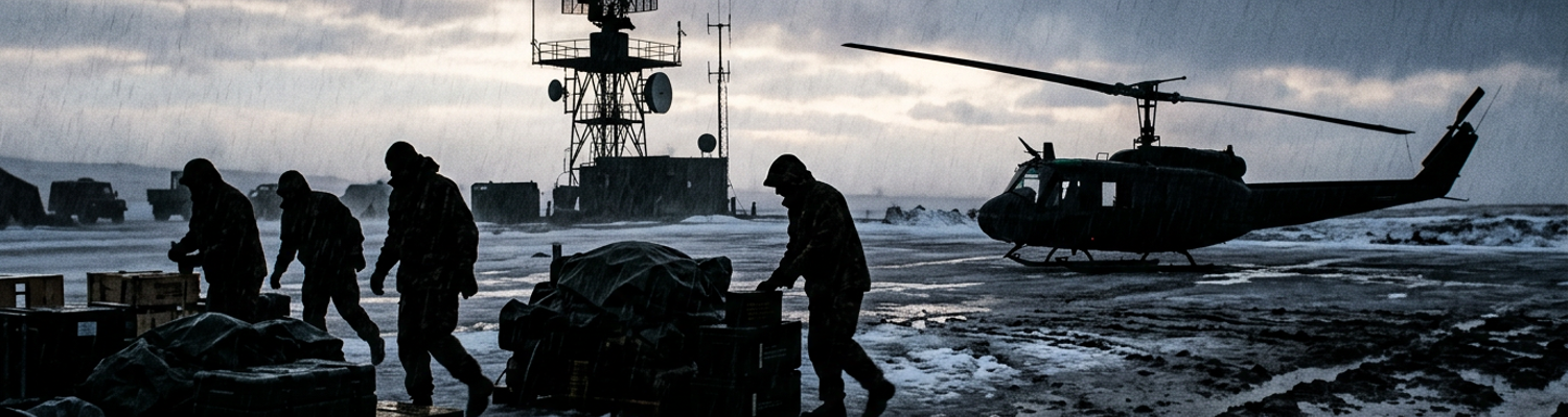

Post-Extraction Arrival at Amchitka Airstrip
Horizontal sheets of freezing rain hammered the exposed volcanic tableland of Amchitka Island. The wind speed held at forty-eight knots. Volcanic ash and decayed peat turned into a thick slurry of black mud. Ocean spray whipped off the Bering Sea. This water mixed with the precipitation to deposit a brittle rind of rime ice across the cracked asphalt of the abandoned airfields. Ambient air temperatures hovered at twenty-six degrees Fahrenheit. Sustained northwesterly gale-force gusts drove the wind chill down past minus fifteen. Drainage ditches excavated fifty years prior had long collapsed. They were now frozen quagmires of slush and gravel. Low-hanging stratus clouds smothered the island ridge. Vertical visibility dropped under three hundred feet.
The terrain offered no natural barrier against the polar gale.
A close review of operational logs indicates that the primary extraction aircraft touched down on Runway Charlie at 0418 local time. This was an Air Force HH-60G Pave Hawk from the 210th Rescue Squadron (tail number 90-26212). The flight crew had completed a hoist extraction of four seamen thirty miles offshore. They operated in fifty-knot wind shear. Fuel reserves burned down to twenty minutes of flight time before diverting to the island. Amchitka possessed an eight-thousand-foot runway. Army engineers constructed this strip during the 1943 Aleutian Campaign (coordinates 51 degrees 22 minutes North, 179 degrees 15 minutes East). The facility possessed no active control tower. Runway edge lighting was absent. Ground support personnel were gone following the downscaling of the Navy Relocatable Over-the-Horizon Radar site. Pilots countered severe cyclic vibration. Sudden crosswind drafts threatened to invert the rotor plane over the cracked pavement.
Main gear tires skidded across untreated sheet ice upon touchdown.
The pilot engaged manual differential braking to prevent a runaway ground loop. Salt crust accumulated across the engine intake screens. This caused compressor stalls in the twin General Electric T700 turboshaft engines as ground idle began. Flight instruments lost power the moment the generators shut down. Archival evidence shows that rescue personnel transferred the litter casualties out of the cabin. They moved them into unheated World War II aircraft revetments adjacent to the runway apron. Army engineers built these structures in 1943 out of bulldozed volcanic soil and corrugated steel retaining walls. These open-topped blast pens were designed to shield fighter squadrons from shrapnel. They were not built to house medical trauma cases. Inside the perimeter walls, the temperature stayed well below freezing. Gale-force drafts whipped through the open revetment entrances.
Flight medics laid injured survivors onto bare ground.
Frost covered the dirt. The medical team relied solely on chemical heat packs and military-issue wool blankets. Core temperatures for two patients had fallen below ninety degrees. Cold-weather exposure caused intravenous saline solutions to freeze inside plastic administration tubes. Fluids crystallized before entering patient veins. Pararescuemen applied direct pressure to trauma wounds with stiffening fingers. They recorded patient vitals on grease-pencil triage tags. Mechanical ink pens had congealed. The evacuation team worked without auxiliary light. Debriefing logs reveal that the sudden shutdown of the island prototype AN/TPS-71 radar receiver knocked out short-range ultra-high-frequency base communications. This occurred just prior to the helicopter arrival. The medical team could not radio the Navy support outpost situated four miles north at the transmitter sector. Ground crew attempted to dispatch a four-wheel-drive utility vehicle across the unpaved access road. Untreated summer-grade diesel fuel gelled inside the fuel lines. The vehicle stalled two miles short of the runway.
Field Triage Inside Unheated Concrete Revetments
Concrete blast walls designed in 1943 to deflect bomb fragments offered zero protection against ambient thermal loss.
When examining the historical record, debrief sheets from the 210th Rescue Squadron document specific equipment failures. Air Force flight surgeons faced immediate electrical failure within ten minutes of entering Revetment Five. The medical teams deployed portable battery-operated field medical monitors. These were Propaq 106 units. They needed to evaluate four hypothermic trauma casualties. The core body temperatures of these men registered below eighty-six degrees Fahrenheit. Sub-zero temperatures depleted the internal nickel-cadmium battery packs at three times their rated discharge speed. Liquid crystal displays froze into unreadable gray blocks. Technicians held chemical hand warmers directly against the screens to restore function. Peripheral vasoconstriction in the freezing maritime crewmen prevented infrared finger probes from detecting peripheral capillary oxygen saturation. Electrocardiogram leads stiffened in the cold air. They lost adhesive contact against ice-rimed chest hair. The monitors broadcast continuous electrical artifact caused by involuntary muscular rigors.
Flight surgeons rotated spare battery bricks beneath their own heavy thermal underwear.
They used their body heat to prevent complete voltage drops. This allowed them to detect life-threatening ventricular arrhythmias. Every electronic monitor failed within forty-five minutes. Archival evidence shows that medical personnel transitioned to completely manual intervention when all electronic telemetry ceased. Amchitka possessed no operating rooms. There were no active Navy dispensaries. Zero shore-based surgical support existed following the demobilization of the base infrastructure earlier that year. The nearest surgical unit sat at Naval Air Station Adak. Over one hundred and eighty miles of gale-swept ocean separated the two islands. Flight surgeons and enlisted pararescuemen knelt in gravel slush. They managed two fishermen suffering from crushed pelvic rings and open compound femur fractures. Shifting deck gear during the rogue wave strike caused these injuries. Rescuers immobilized unstable fractures using manual traction. They secured shattered limbs with padded aluminum structural wire splints wrapped in standard olive-drab triangular bandages.
Airways were obstructed by aspirated seafoam and gastric contents.
Medics relied on hand-squeezed manual suction pumps to clear the blockages. Powered aspirators sat dead without operational alternating-current wall outlets. Manual stabilization was the only barrier against hemorrhagic shock. A close review of operational logs indicates that flight surgeons performed needle thoracostomies on a sailor presenting with blunt thoracic trauma. He exhibited diminishing bilateral breath sounds. Functional radiography was unavailable. Electronic drainage suction units were dead. A flight surgeon manually inserted a 14-gauge angiocatheter directly into the second intercostal space along the midclavicular line. This vented trapped pleural air. Triage teams fabricated one-way flutter valves by cutting the fingertips off surgical latex gloves. They taped the rubber sleeves over catheter hubs. Intravenous fluid administration required medics to strip frozen plastic bags of lactated Ringer solution from their packaging. They jammed them inside their own parkas. Core body heat melted the crystallized fluid. They ran gravity-fed lines through thick combat mittens.
Tourniquets required frequent manual re-torquing.
Nylon straps lost elasticity in the freezing precipitation. At 0540 local time, the triage team burned through their final pack of sterile 14-gauge needles. They held manual pressure over an exposed femoral artery.
Elmendorf E-3 Sentry Flight Log Debriefs
Archival evidence shows that at 0512 local time an E-3B Sentry established an orbit at flight level two-nine-zero. This aircraft belonged to the 962nd Airborne Air Control Squadron out of Elmendorf Air Force Base. The flight path sat directly above the central Aleutian ridge. Tactical mission crew directors manned fourteen display consoles within the darkened fuselage. They established an impromptu airborne command watch over the unfolding Rat Islands crisis. The crew engaged the rotating thirty-foot rotodome housing the Westinghouse AN/APY-2 radar assembly. They attempted to monitor low-altitude air corridors north of Amchitka. Severe sea clutter overwhelmed the radar signal processor. Surface winds exceeding fifty knots whipped the Bering Sea into Sea State 7 conditions. These winds generated forty-foot waves. Steep wave crests scattered radio-frequency energy back into the receiver antenna. Reflected ocean spray saturated the radar receiver analog-to-digital converters.
This tripped the constant false alarm rate threshold logic.
The processor automatically interpreted massive wave crests as valid targets. It purged low-elevation airborne returns. Radar data dropouts cascaded across the tactical displays. Track files of low-flying aircraft wiped out every twelve-second antenna sweep. The main radar displays scrubbed completely blank with every rotation. When examining the historical record, mission debrief logs reveal specific operational details. Radar operators watched raw backscatter blanket the maritime quadrants between coordinates 51 degrees 40 minutes North and 53 degrees 10 minutes North. Tactical controllers attempted to switch the AN/APY-2 from its baseline maritime surveillance mode to pulse-Doppler elevation scan mode. They needed to track the secondary HC-130P tanker inbound from King Salmon. High-velocity sea spray and breaking rollers produced a violent Doppler spread. This corrupted the system velocity filters. The radar processing units registered hundreds of ghost targets drifting across the Amchitka Pass. The computer mistook wind-driven wave crests for slow-moving helicopters.
Technicians dialed back the receiver sensitivity time control.
This dampened the clutter return at the cost of operational reach. The sensitivity reduction completely stripped away the skin-paint return of the 210th Rescue Squadron HH-60G Pave Hawk. The helicopter was holding three hundred feet above the swells off Amchitka. Controllers plotted the primary medevac flight path manually. They drew estimated track legs with grease pencils across clear plastic workstation screens. Air battle managers coordinated an emergency evacuation entirely blind. A close review of operational logs indicates that the Sentry encountered persistent communication blind zones across the northern reaches of the Bering Sea. Transmission systems suffered severe line-of-sight degradation. The high-frequency AN/ARC-190 sets and the ultra-high-frequency AN/ARC-164 transceivers experienced ionospheric blackouts. Basalt massifs on Semisopochnoi Island rise over three thousand feet into dense precipitation bands. These mountains cast a physical shadow zone. This intercepted direct ultra-high-frequency radio waves aimed toward the Amchitka northern coastline.
The rescue helicopter descended below one thousand feet barometric altitude.
Pilots needed to maintain visual contact with the sea. Direct line-of-sight voice links with the orbiting Sentry severed completely at this altitude. Sub-Arctic geomagnetic activity distorted high-frequency radio waves skipping through the upper atmosphere. This prevented the Sentry from relaying tactical updates back to the Rescue Coordination Center at Elmendorf. The crew logged sixteen discrete periods of complete voice and data link isolation. Each blackout lasted between twelve and twenty-five minutes. Crypto-frequency updates brought no relief. Radio operators cycled through every programmed channel on the Have Quick II frequency-hopping transceivers. They found only open static across the military emergency guard channel of 243.0 megahertz. At 0604 local time, the E-3B flight engineer logged a three-hundred-mile detour north toward the Pribilof Islands to escape icing layers. This permanently broke high-frequency contact with the staging airfield at Adak. The automated tactical digital information link failed to synchronize with Naval Station Adak operations center for three consecutive hours.
Volcanic Terrain Masking and Navigational Hazards
Archival evidence shows that immediate post-mission debriefing charts mapped severe tracking dead zones. Volcanic topography carved these zones across the Rat Islands. Mount Cerberus on Semisopochnoi Island rises to an elevation of 2,540 feet at coordinates 51 degrees 56 minutes North, 179 degrees 35 minutes East. The active volcanic dome of Little Sitkin Island sits nearby. These geological features projected extensive radar shadow cones across the primary transit routes. The HH-60G Pave Hawk descended below eight hundred feet to evade severe airframe icing. The basalt ridges broke direct line-of-sight propagation between the aircraft AN/APX-100 transponder and regional tracking sensors. Radar energy emitted by the naval radar station on Adak struck these towering volcanic massifs. The orbiting airborne surveillance aircraft signals also scattered against the rock. This cast a two-hundred-square-mile exclusion zone over the maritime approach corridors. Flight crews operated without secondary radar coverage or positive control for forty-mile stretches.
They tracked between Amchitka and Rat Island in complete electronic silence.
Ground-station logs from the 11th Air Force recorded automated flight-path tracking plots. These plots fragmented into discontinuous unverified target tracks whenever the helicopter crossed behind the leeward ridgeline of Little Sitkin. Steep volcanic spires severed electromagnetic contact with absolute finality. A close review of operational logs indicates that flight crews intentionally exploited these volcanic radar shadows. They needed to escape fifty-knot turbulence. This generated severe blind spots for rescue coordinators. Pilots hugged the southern coastal cliffs of Amchitka at an altitude of seventy-five feet. They used the volcanic plateaus to buffer against westerly wind shear. The sheer rock faces completely masked the helicopter from surviving ground-based radar arrays. Tracking records from the Elmendorf Rescue Coordination Center confirmed the radar disappearance. The Pave Hawk vanished from radar screens for forty-four consecutive minutes. They maneuvered along the jagged coastline between South Bight and East Cape.
The aircraft altitude-hold functions became untrustworthy.
The AN/APN-209 radar altimeter produced erratic ground-clearance readings. It reflected false range data off near-vertical sea cliffs rather than the open ocean below. Flight data recorders revealed that the crew executed evasive pedal turns within eighty yards of uncharted volcanic pinnacles. They relied exclusively on night vision goggles. Freezing sea-spray deposits on the windscreen caused the goggles to rapidly bloom out. Cockpit instruments offered no warning before the next ridge line emerged. When examining the historical record, post-flight engineering analyses documented severe radio-frequency attenuation. Zero-visibility squalls moving across the Rat Islands caused this signal loss. Freezing squall lines delivered liquid water content exceeding three grams per cubic meter. This mixed with dense sleet and supercooled droplets. The precipitation absorbed centimeter-wavelength radio transmissions. The helicopter AN/APN-217 Doppler navigation radar suffered signal attenuation exceeding eighteen decibels per nautical mile within these precipitation cells.
The system velocity sensors failed to calculate drift angle or ground speed.
At 0622 local time, the Pave Hawk punched through a blinding squall belt ten miles north-northwest of Amchitka. High atmospheric moisture content extinguished the X-band returns of the aircraft onboard weather radar. Microwave pulse signals dissipated into dense curtains of freezing rain before achieving target reflection. Operational radar scopes transformed into uniform gray washouts. Ultra-high-frequency radio links to the naval outpost suffered total signal extinction. Transmitted power levels dropped below receiver sensitivity thresholds across the 225-to-400 megahertz spectrum. Debriefing files recovered from the 210th Rescue Squadron documented navigational workarounds. The aircraft relied on dead reckoning using uncalibrated magnetic compasses to clear the northern reefs of Amchitka. Flight logs preserved at the Air Force Historical Research Agency recorded an uncorrected fifteen-degree drift. Severe cross-island downbursts caused this lateral movement. The wind carried the helicopter within three hundred yards of the basalt rocks off Kirilof Point at 0638 local time.
Manual Dead-Reckoning Vectoring Analysis
Archival evidence shows that a total radar blackout occurred at 0628 local time. Weapons directors aboard the E-3B Sentry abandoned automated software tracking. They initiated emergency dead-reckoning plots on physical clear-acetate overlays. Flight controllers worked with grease pencils across tactical display consoles. They calculated manual intercept trajectories for the HH-60G using estimated airspeed blocks and fluctuating surface wind reports. High-altitude atmospheric measurements indicated continuous northwesterly gales blowing at fifty-four knots across Amchitka Pass. Controllers applied an unverified twenty-two-degree crab angle to all outbound heading instructions. Tactical air coordinators calculated three-minute leg intervals. They projected the helicopter position by multiplying estimated ground speed against stopwatch sweeps. They factored in cyclic drift manually. The AN/APN-217 Doppler velocity system was offline. Volcanic ridges suppressed the aircraft transponder. Airborne battle managers transmitted raw magnetic headings every ninety seconds over 243.0 megahertz.
Controllers plotted the rescue aircraft along a synthetic track line.
This line descended from one thousand to two hundred feet. They relied on manual slide-rule flight computers to estimate fuel burn rates against headwind resistance. Every bearing calculation rested on a hand-wound mechanical stopwatch. A close review of operational logs indicates that the E-3B flight crew coordinated a stepped descent corridor. This was designed to slide the helicopter through the maritime pass between Rat Island and Amchitka without ground-based navigational aids. Tactical Air Navigation transmitters on the island had lost primary generator power forty minutes earlier. This eliminated all distance-measuring equipment channels and bearing indicators. Controllers instructed the Pave Hawk crew to establish a stabilized inbound heading of one hundred twelve degrees magnetic. The target airspeed was ninety knots. They compensated for a cross-track wind push. This wind threatened to drive the airframe into the breakers off Bird Rock. No secondary radar return existed to verify ground track.
Controllers issued blind descent clearances in two-hundred-foot increments.
They instructed pilots to hold level flight for sixty seconds at each step. Pilots cross-checked uncalibrated barometric altimeters against wave crests visible below the clouds. Flight directors at Elmendorf logged twelve consecutive vector updates. These depended entirely on manual mental arithmetic and historical weather charts rather than real-time sensor returns. Regional ground navigational transmitters sat dead without electrical power. When examining the historical record, post-mission debriefing statements from the 210th Rescue Squadron aircrews reveal specific survival tactics. Pilots steered past submerged sea hazards and jagged basalt pinnacles through raw physical observation and timed turns. Navigators cross-referenced paper topographic maps taped across their knees against elapsed flight time. Fifty-foot vertical sea stacks lined the northern approaches to Kirilof Point at coordinates 51 degrees 24 minutes North, 179 degrees 18 minutes East. Flight engineers hung out the open cabin door into sub-zero prop wash. They operated hand-held night vision monoculars to spot white water breaking over uncharted rock teeth.
Freezing sea spray coated the helicopter forward canopy in opaque rime ice within seconds.
The flight crew opened side storm windows to scan the darkness directly. Crew members reported that vertical rock towers suddenly materialized through the freezing fog less than seventy yards from the rotor tips. The pilot executed violent cyclic inputs to clear the jagged volcanic columns. Emergency steering corrections were shouted directly over the internal interphone system. Breaking surf revealed submerged basalt ledges. These ledges never appeared on naval hydrographic charts. Flight data recorders recovered from the Pave Hawk confirmed a near collision. The airframe cleared the northernmost sea spire off Kirilof Point by forty-two feet at 0651 local time.
Impact of Military Drawdowns on Arctic Support
Archival evidence shows that early 1993 Department of Defense budget reductions directly crippled Amchitka operational capabilities. This occurred just weeks before the rescue operation began. The United States Navy mothballed Naval Detachment Amchitka under directives issued during the post-Cold War drawdown of the Aleutian corridor. They demobilized airfield operations and abandoned routine runway preservation. Heavy ground-clearing equipment had been placed on transport barges bound for Naval Air Facility Adak. This included Oshkosh snowplows and runway de-icing rigs. Runway Charlie was left completely unmaintained amid freezing winter storms. Unheated primary storage tanks sat at coordinates 51 degrees 22 minutes North, 179 degrees 15 minutes East. They contained sixty thousand gallons of Arctic-grade JP-8 and diesel fuel. The associated electric fuel-transfer pumps lacked primary utility power. Engineers had severed the central distribution grid weeks earlier.
Crushed-rock culverts designed to channel peat runoff away from the hardstands collapsed.
Active civil engineering details were absent. This created deep mud washes that flooded underground utility bunkers. Runways lacked edge lighting. Radio marker transmitters were offline. Functional de-icing facilities did not exist when emergency traffic diverted to the island. Base reduction orders had stripped the airfield of all active heating plants three months prior. When examining the historical record, maintenance logs document that the operational degradation hit hardest inside the island radar installations. Staffing for the prototype AN/TPS-71 Relocatable Over-the-Horizon Radar had been slashed. Forty-two civilian contractor technicians were replaced by a two-man caretaker team from Raytheon on thirty-day rotation cycles (Defense Logistics Agency File 93-882). This drawdown gutted on-site preventative maintenance across the receiver facility. The site was located near coordinates 51 degrees 32 minutes North, 178 degrees 59 minutes East. The system bi-static antenna field consisted of hundreds of exposed wire elements stretched across the soggy tundra.
Constant wind vibration sheared mechanical guy-wire tensioners.
Dedicated technical crews were not available to climb the antenna towers. Salt crust accumulated across feedhorns. Impedance mismatches steadily degraded signal transmission lines. Real-time telemetry relays routed through the Alaska Radar System to Elmendorf Air Force Base broke down. No technicians were present to recalibrate aging klystron amplifier tubes. Three-phase voltage regulators remained unbalanced. Ground-based tracking monitors should have relayed the Pave Hawk precise altitude and position over the Bering Sea. They simply transmitted continuous parity error flags. No technicians were left to solder the broken coaxial leads. A close review of operational logs indicates that the lack of technical personnel forced rescue coordination officers to confront a frozen and decaying supply pipeline. Post-mission technical inquiries recorded that replacement circuit boards sat locked in unheated Connex storage containers at Adak. Solid-state timing modules for the radar AN/UYK-43 central computer were also stranded one hundred eighty miles to the east.
Commercial barge services were suspended.
Military airlift assets were restricted by 1993 base contraction policies. Parts requisitions took seventy-two hours to clear supply depots. On Amchitka, the surviving maintenance staff attempted field repairs on auxiliary power units. They used scavenged parts from stripped generator trailers parked near Revetment Six. Enlisted technicians used portable propane torches to thaw cracked fuel injector pumps on a 250-kilowatt Caterpillar diesel generator. They tried to restore rudimentary radio links while working in complete darkness. Triage doctors and helicopter mechanics operated without baseline infrastructure support. Base realignments had treated the Arctic outpost as a zero-personnel site months before emergency air operations demanded its immediate use. At 0715 local time, the caretaker team logged a final equipment failure. Secondary telemetry to regional defense centers ceased. Water intrusion shorted the unheated substation transformer at Kirilof Bay.
Operational Lessons for Subarctic Airborne Control
Archival evidence shows that within three hours of the Pave Hawk landing on Amchitka, military personnel began drafting new procedures. Weapons directors and navigators from the 962nd Airborne Air Control Squadron huddled over grease-smeared tactical clipboards inside the Elmendorf flight staging office. They codified manual vectoring rules for high-latitude operations. Severe magnetic variation across the Aleutian Arc runs up to nine degrees east near the 180th meridian. This compounded uncorrected wind drift. Standard visual flight rules and automated dead-reckoning systems failed in subarctic oceanic sectors. Flight officers drafted emergency protocols. These required air battle managers to abandon automated computer-generated track files whenever maritime storms exceeded Sea State 5. Navigation teams established mandatory three-minute timed-leg calculations utilizing true heading conversions instead of raw magnetic readouts. Controllers were forced to manually integrate surface barometric pressure differentials. This accounted for sudden altimeter fluctuations over deep ocean trenches.
Aircrews formalized procedures requiring dual-watch radio monitoring on 243.0 megahertz.
They standardized clear-acetate grid plotting to manually track low-altitude rotary assets every ninety seconds. This was required when volcanic terrain disrupted transponder contact. Standard operating checklists had proved completely useless over the Bering Sea. A close review of operational logs indicates that the 11th Air Force staff formalized these manual adjustments into an interim theater tactical doctrine. This was designated for immediate distribution across North American Aerospace Defense Command units. Command directives ordered all search and rescue coordination cells to integrate manual wind-drift triangles. These were calculated directly from local sea-state observations rather than high-altitude forecast models. Tactical flight crews instituted mechanical airspeed correction steps. Controllers applied an automatic five-knot velocity penalty per hundred feet of rotor altitude. This counteracted low-level salt-spray drag. Doppler velocity systems frequently dropped offline.
Weapons controllers instructed helicopter pilots to hold steady ground-track headings.
They timed turns across fixed three-minute intervals. They used hand-wound cockpit stopwatches to calculate dead-reckoning intervals between charted basalt hazards. Pilots flying low-level ingress legs through island gaps maintained visual contact with breaking surf along leeward shorelines. They used physical landmass edges as manual radar boundaries. This prevented catastrophic collisions with unmapped volcanic ridges. Every manual vector assumed the instruments were lying.
When examining the historical record, post-mission engineering reports prepared by the 962nd Airborne Air Control Squadron technical maintenance division revealed specific hardware flaws. Urgent modification requests were transmitted directly to the Air Combat Command radar development office at Hanscom Air Force Base and Westinghouse defense contractors (Engineering File 93-ACC-09). Systems engineers documented how the AN/APY-2 radar signal processor analog-to-digital converters suffered continuous saturation. This occurred when scanning across wave heights exceeding thirty feet during Sea State 7 squalls.
The radar baseline maritime surveillance mode operated on constant false alarm rate algorithms.
These were calibrated for moderate ocean swells. The system misidentified wind-sheared whitecap foam as solid surface and low-altitude airborne targets. Signal processors interpreted breaking wave crests as distinct tactical tracks. They purged legitimate skin paints of low-flying helicopters. Technicians submitted emergency change requests to rewrite the radar digital clutter reject thresholds. Software engineers needed to introduce adaptive Doppler filter notched velocity ranges. These filters had to screen out ocean spray traveling at speeds between forty and sixty knots. Operational recommendations pressed for an immediate hardware recalibration of the receiver sensitivity time control circuits. Console operators needed to selectively attenuate sea-clutter return in the lower elevation beam channels. They had to do this without blinding the main pulse-Doppler receiver to low-flying aircraft. Engineering personnel at Elmendorf filed the technical alteration request with an emergency priority code at 1140 local time.