
The Unseen Vanguard
In the decades after the American Civil War, as the United States turned its industrializing gaze westward, the U.S. Army was already there. Its role, however, was transforming. Beyond the forts and the columns of cavalry, a new mission took shape, one fought not with carbines and sabers, but with theodolites, geological hammers, and mule-drawn wagons packed with scientific instruments. This was the era of the great geological and geographical surveys, a period where Army officers, often commanding civilian scientists, became the nation’s premier mineral scouts. Their objective was to locate the raw materials of empire: the iron, coal, and copper needed to fuel the Gilded Age and build a modern military machine. These expeditions, operating under the authority of the War Department, were instruments of national policy, tasked with quantifying the vast, contested lands west of the 100th meridian.
This blend of military command and scientific inquiry was a strategic imperative. Men like Clarence King, Ferdinand V. Hayden, John Wesley Powell, and Lieutenant George M. Wheeler led what became known as the "Four Great Surveys of the American West." While King, Hayden, and Powell were civilians, their work was deeply intertwined with the military. They relied on Army escorts for protection, Army logistics for supply, and operated under the broad oversight of the Army Corps of Engineers, led by Brigadier General Andrew A. Humphreys. Wheeler’s survey was explicitly a military operation from the start, a project of the Corps of Engineers designed to produce maps for military planning. The rationale was clear. To control the West, the Army needed to understand its geography. To power the nation’s industrial expansion, it needed to find the mineral wealth hidden within that geography. This was a new kind of reconnaissance, where the prize was not intelligence on enemy positions, but the location of a coal seam that could power a railroad or a copper deposit for telegraph wires.
This work was carried out in a landscape that was far from empty. The lands being mapped for their resource potential were the homelands of numerous Indigenous tribes, many with treaties guaranteeing their rights to the territory. The survey parties were, in effect, the leading edge of a resource rush that would dispossess these tribes. The geologists and their military escorts operated in a complex ethical gray zone. They were professionals and scientists, performing a government mandate to chart the unknown and secure the nation’s future. They were also the agents of an expansionist power, their discoveries often leading directly to broken treaties, conflict, and the erosion of Native American sovereignty. The story of the Army’s mineral scouts is therefore not just one of scientific discovery and logistical grit. It is a story about the core conflicts of the Gilded Age: the drive for industrial power, the doctrine of manifest destiny, and the human cost of a nation’s relentless push westward.
Forging the Mission
The formal authorization for these large-scale, geology-focused explorations began in earnest on March 2, 1867. On that day, Congress authorized two foundational projects. The first was a geological survey of Nebraska under the General Land Office. The second, and more consequential for the military, was a survey under the Corps of Engineers to study the geology and natural resources along the 40th parallel. This route was not chosen at random; it was the path of the transcontinental railroad, a vital piece of national infrastructure that the War Department had a vested interest in securing and supplying. Clarence King, a young, ambitious civilian geologist from Yale’s Sheffield Scientific School, conceived and successfully pitched this survey to the War Department. His Geological Exploration of the Fortieth Parallel, though led by a civilian, was established by order of the Secretary of War and operated under the direction of General Humphreys, Chief of the Corps of Engineers.
At the same time, Ferdinand V. Hayden, a veteran of earlier explorations with the Topographical Engineers, began his own surveys under the Department of the Interior. Though a civilian enterprise, Hayden’s expeditions frequently benefited from military escorts and his work was part of the same national push for resource assessment. His 1871 expedition to the Yellowstone region, which included the painter Thomas Moran and photographer William Henry Jackson, received federal funding and led directly to the creation of the world’s first national park. Hayden’s teams documented vast coal fields and iron deposits, information of direct value to military and industrial planners.
The most overtly military of the four was the U.S. Geographical Surveys West of the 100th Meridian, commanded by First Lieutenant George M. Wheeler. Authorized in 1872, Wheeler’s mandate was sweeping. His primary goal was to create detailed topographic maps for military use. His orders, however, went much further. He was to report on the numbers and disposition of Indian tribes, identify locations for future military posts, evaluate potential routes for roads and railways, and document all mineral resources, water sources, and agricultural potential. Wheeler’s project was the Army’s direct answer to the civilian-led surveys, an assertion by the Corps of Engineers under General Humphreys that mapping and assessing the West was a core military function. This created a fierce rivalry between Wheeler, Hayden, and Powell, each vying for congressional funding and prestige. The competition, while personal, drove the frantic pace of exploration and data collection that defined the era.
These were not abstract scientific pursuits. The Army sought specific resources. Coal was paramount, needed to power the steam locomotives of the new railroads and the engines of a modernizing Navy. Iron was the backbone of industry and armament, essential for everything from rails to cannons. Copper was the nerve fiber of the new age, required for telegraph wires that allowed for command and control over vast distances. The reports filed by King, Hayden, and Wheeler were not just geological treatises. They were strategic documents, catalogs of the material foundations for America’s future power. King's first major report, "The Mining Industry" (1870), was a utilitarian guide to the mineral wealth of the West.
The Weight of Discovery
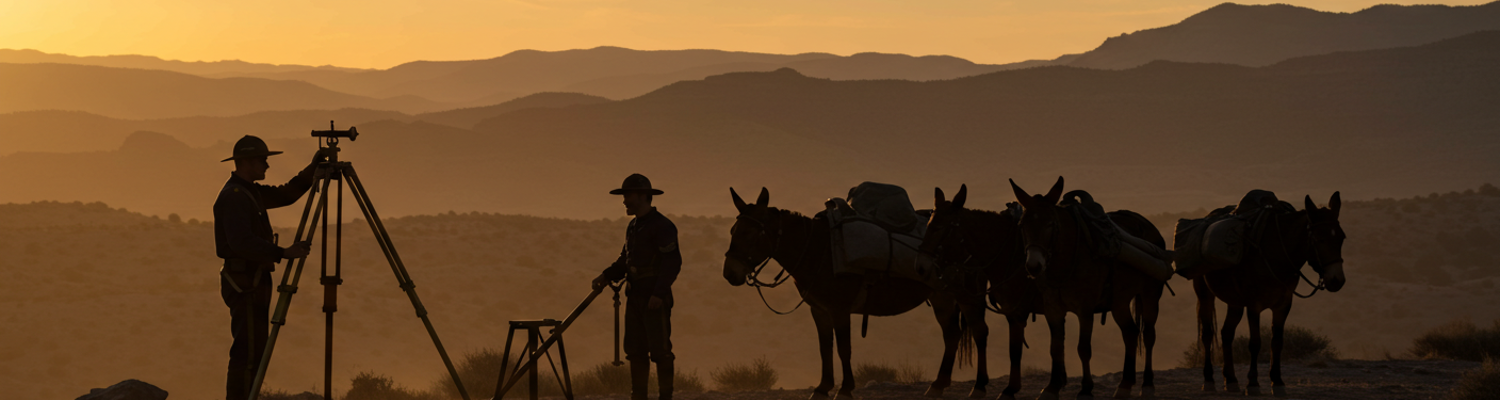
A survey expedition in the 1870s was a complex, mobile operation, a testament to logistical fortitude. A typical party under Wheeler or King was a hybrid entity, part military unit, part scientific laboratory. It comprised a core of Army engineers or civilian scientists, topographers, geologists, and naturalists. These specialists were supported by packers, cooks, and teamsters, and almost always protected by a detachment of U.S. Army cavalry or infantry. Artists and photographers, like the celebrated Timothy H. O'Sullivan who worked with both King and Wheeler, were also integral members, their images providing visual proof of the landscapes and discoveries.
The equipment they carried was both essential and burdensome. The primary instruments for mapping were theodolites and transits, heavy brass instruments used for measuring horizontal and vertical angles. These had to be painstakingly set up on high peaks to create a web of triangulation points. Fragile mercurial barometers were necessary to determine altitude, but they had to be transported with extreme care by men who understood the instruments' sensitivity; a single stumble could render a season's worth of altitude readings useless. Chronometers for determining longitude, sextants, compasses, and measuring chains were all part of the topographer's kit. Geologists carried hammers, chisels, and heavy canvas bags for collecting rock and fossil specimens. A single mule might carry two hundred pounds of carefully labeled rock, a geological library on four hooves. The expedition photographer, often O'Sullivan, wrestled with a portable darkroom, a bulky wooden camera, and heavy glass plates that required the difficult wet-plate collodion process. Each photograph demanded coating, exposing, and developing the plate on site, an ordeal that could take hours under harsh field conditions.
The sheer mass of this equipment, along with food, ammunition, and camp supplies for dozens of men for months at a time, had to be transported across some of the most difficult terrain in North America. The workhorse of the surveys was the pack mule. Mule trains, sometimes numbering over a hundred animals, were the only way to move tons of gear through narrow canyons, over high mountain passes, and across waterless deserts. The daily routine was a grueling cycle of packing, marching, and unpacking. A dropped crate could mean the destruction of a priceless chronometer or a month's worth of photographic plates. A mule slipping on a high trail could send a season's worth of geological samples plunging into a ravine.
The military escort’s role was far more than just guard duty. The soldiers were often the most experienced trailblazers and provided the discipline and manpower that held the expedition together. They scouted the routes, cleared paths, managed the livestock, and provided the security that allowed the scientists to do their work. Encounters with Native American groups were frequent, and while many were peaceful, the potential for conflict was a constant reality. The surveys were trespassing on tribal lands. Their purpose, cataloging the resources of those lands for others, was an inherent threat. The presence of uniformed soldiers underscored the fact that these scientific missions were backed by force. The ethical line was continually blurred as the pursuit of knowledge became indistinguishable from the projection of military power.
From Survey to Settlement
The data hauled back from the West did not sit in archives. It was immediately put to use, shaping the physical and political landscape of the nation. The connection between survey findings and tangible development was direct. The maps and mineral reports from the Army-led surveys functioned as a blueprint for the industrial development of the West.
Clarence King’s survey along the 40th parallel had the most immediate economic impact. His team’s identification of vast coal deposits in Wyoming and Utah was a critical development for the Union Pacific Railroad, which was building its line directly through that territory. These coalfields provided the fuel that allowed the railroad to operate and expand, turning a transportation corridor into a lifeline for settlement and industry. King's reports on mineral districts like the Comstock Lode in Nevada guided investment and technology, accelerating the extraction of wealth from the region.
Lieutenant Wheeler’s work had a more explicitly military application. His detailed topographic maps, produced at a scale of eight miles to the inch, were the most advanced military mapping products of their day. Army commanders like General George Crook used them to plan campaigns and to strategically locate new forts during the Sioux and Apache Wars. A Wheeler map showing mountain passes, water sources, and grazing lands was an invaluable tool for controlling the movement of both U.S. troops and Native American warriors. Forts were placed to dominate key valleys and river junctions identified by the surveys, projecting military power deep into previously remote territories and constricting the freedom of Indigenous peoples. The maps facilitated the very military campaigns that would enforce the policies enabled by the surveys’ discoveries.
The most notorious consequences arose when mineral discoveries collided with treaty obligations. Hayden’s explorations in the Black Hills, followed by George Armstrong Custer’s more famous 1874 reconnaissance which confirmed the presence of gold, ignited a firestorm. The Black Hills were sacred to the Lakota and guaranteed to them by the Fort Laramie Treaty of 1868. The confirmation of gold, a fact established by government-sponsored surveys, triggered a massive, illegal influx of white miners. The Army, which had recently mapped the territory, was now tasked with protecting the miners and forcing the Lakota onto smaller reservations. The resulting conflict, the Great Sioux War of 1876, was a direct outcome of the resource-driven exploration that the Army itself had pioneered.
Drawing the Lines of an Empire
The work of the Army’s mineral scouts and the great surveys of the Gilded Age produced an immense body of scientific knowledge. They created the first systematic geological and topographical maps of the American West, providing a foundation for the U.S. Geological Survey (USGS), which was formally established in 1879 by consolidating the various survey efforts. The data they collected on mineral resources, hydrology, and agriculture drove the economic development of the nation. Men like John Wesley Powell used their experience to develop farsighted ideas about land use and water conservation in the arid West, even if their advice was largely ignored at the time.
This progress came at a significant cost. The surveys were an integral part of westward expansion, a process that involved the subjugation and displacement of Native American populations. The identification of strategic resources was a key step in claiming the land, not just in theory but in practice. The geologists and soldiers who conducted the surveys were the vanguard of an industrial nation that saw the West as a repository of raw materials to be exploited. Their maps and reports, while scientifically valuable, were also tools of empire, facilitating the transfer of land and resources from Indigenous hands to those of the government and private corporations.
The individual motivations of the men involved remain a matter of historical debate. Many, like Powell, developed a deep respect for the Native American cultures they encountered and became advocates for ethnological study. Others, like Wheeler, maintained a rigid military perspective, viewing the land and its inhabitants through a lens of strategic objectives. Most were likely professionals focused on the immense challenges of their immediate tasks: climbing a peak for a triangulation reading, protecting a pack train from ambush, or chipping a fossil out of a rock face. They operated in the space where scientific discovery, military ambition, and economic expansion converged. The mineral scouts of the Gilded Age Army were not simply mapping rocks. They were drawing the borders of the modern American military-industrial state, on a landscape that would be forever altered by their work.