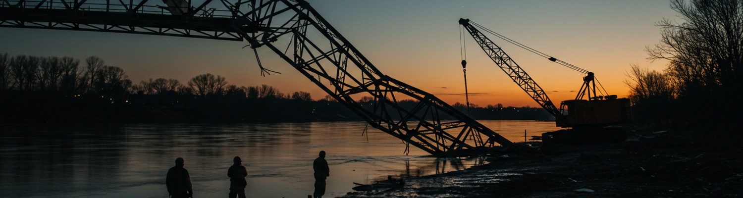

The failure began with a high-pitched metallic scream. A forensic engineering review, compiled months later (NARA Record Group 338, Annex C), pinpointed the origin. It was a northern abutment’s primary load-bearing pin on the Musa Qala-Sangin span. Decades of Helmand seasons, from baking summers to flash-flood winters, had accelerated deep corrosion. The steel, improperly graded during a hasty Soviet-era installation, gave way. It was under the combined weight of a civilian grain truck and a US Marine Corps MRAP All-Terrain Vehicle from Task Force 3/5’s logistics patrol. For 1.7 seconds, the bridge held in a state of impossible tension. A deep groan echoed down the river valley before the entire western truss buckled inward with a deafening concussion. Steel girders, thick as a man’s torso, twisted and tore apart. The reinforced concrete deck disintegrated, plunging tons of material and the vehicles upon it into the brown, fast-moving waters of the Helmand River.
The bridge was gone.
Initial casualty assessments were grim. The civilian cost was immediate. On the deck at the moment of failure were at least three vehicles. One was a heavily overloaded Bedford jingle truck, its colorful panels disappearing into the churning water. It took with it the driver, his two sons, and a full cargo of wheat destined for the Gereshk market. Another was an aging Toyota Corolla, a common sight, carrying a family of six from a wedding. Archival evidence from drone overwatch footage, arriving on station seven minutes after the event, shows the car’s chassis mangled on the riverbed. There were no signs of survivors. The third vehicle, a motorcycle and sidecar, was simply obliterated by falling debris. First responder reports from local Afghan National Police units documented a chaotic scene of villagers lining the newly formed chasm. Coalition forces, focused on the recovery of their own vehicle and personnel, could not render immediate, large-scale aid to the civilian victims. Official records put the initial civilian death toll at eleven. At least five more were missing and presumed dead, swept away by the powerful current.
Help was not coming quickly.
For the local population, the collapse was more than a tragedy. It severed their economic and social lifeline. The Musa Qala-Sangin span was the only viable vehicle crossing over a 40-mile stretch of the Helmand River. This geographic artery now acted as an impassable wall. A close review of regional economic data shows the bridge facilitated the daily transport of agricultural goods from the fertile Green Zone of Sangin to the major trading hub at Gereshk. Within 48 hours, farmers in the isolated northern villages found their produce rotting with no path to market. Supply lines for basic medical necessities, including insulin for the small clinic in Musa Qala, were completely cut. The alternative was a treacherous 90-mile detour through a network of wadis and unimproved desert tracks, an area heavily seeded with improvised explosive devices and controlled by insurgent elements. The journey was impossible for the average villager. The bridge’s absence placed thousands of people under a state of geographic siege, isolating them from food, medicine, and family.
From a military perspective, the logistical chain for multiple Coalition forward operating bases snapped. Operational logs for Task Force 3/5, stationed at FOB Erebus north of the river, show an immediate and severe disruption. The bridge had been the primary ground route for resupplying the base with Class III (petroleum, oils, and lubricants) and Class V (ammunition) supplies. Convoys carrying JP-8 fuel for the base’s generators and diesel for its tactical vehicles were forced to turn back. Within hours, FOB Erebus reported a projected 72-hour fuel shortfall. The base commander implemented immediate power rationing. This meant shutting down non-essential systems, including air conditioning in the sweltering heat and power to Morale, Welfare, and Recreation facilities. The disruption threatened the operational tempo of patrols. The fuel to sustain them was now sitting on the wrong side of a river. The collapse forced a sudden and costly reliance on rotary-wing aviation for resupply. Valuable CH-53 Super Stallions were pulled from their primary mission of troop insertion to haul fuel blivets and pallets of MREs.
The autopsy of the Helmand River bridge failure begins not with tearing metal, but in the climate-controlled rooms where intelligence assessments were compiled. Pre-operational planning documents reveal a sequence of miscalculations. The first was a misunderstanding of the bridge’s role in the local society. Intelligence analysts, conditioned to see infrastructure through a military lens, classified the Musa Qala-Sangin span as a Ground Line of Communication. Its value was calculated based on its ability to move troops and supplies. This perspective entirely missed its true function as the central artery of the regional civilian economy. Planners failed to account for the constant, heavy flow of agricultural commerce. They missed the overloaded Bedford and Hino trucks that ferried wheat and produce from Sangin to the Gereshk market. They missed the social importance, where the bridge connected the Alizai and Ishaqzai tribal communities, facilitating travel for weddings, funerals, and family obligations that form the bedrock of Pashtun life. By focusing solely on insurgent vehicle movements, the intelligence picture was dangerously incomplete. This analytical blind spot meant the immense civilian cost of a potential failure was never factored into any risk matrix. There were no contingency plans for managing the economic fallout or the isolation of tens of thousands of civilians.
A second, equally disastrous failure lay in the underestimation of the Helmand River itself. Originating in the Hindu Kush mountains, the river is defined by extreme hydrological volatility. Intelligence reports, likely based on satellite imagery captured during the long, dry summer months, depicted a placid waterway. This snapshot view failed to account for the annual spring freshet, when melting snowpack transforms the river into a violent, debris-filled torrent. Historical hydrological data and local knowledge would have warned of this seasonal surge. The river’s peak flow exerts tremendous force on bridge structures and the riverbed itself, which is composed of soft, alluvial silt highly susceptible to scour. This process erodes material around bridge foundations, leaving them unsupported. The Soviet engineers who hastily installed the bridge likely never conducted a thorough geotechnical survey. Subsequent Coalition assessments failed to identify the progressive, invisible damage happening below the waterline. The very ground the bridge stood on was being washed away season after season, a fact completely absent from operational plans.
The final layer of failure is found in the physical object. The bridge’s site selection was one of convenience, a narrow and seemingly stable choke point. This convenience masked deep-seated vulnerabilities. A proper survey would have flagged the unstable banks and the migratory nature of the river channel. The design was a standard Soviet-era steel truss configuration, likely prefabricated and assembled onsite with speed as the primary concern. Analysis of similar Soviet military bridges from that period reveals a focus on rapid deployment over long-term durability, often using lower-grade steel and non-redundant designs. The load-bearing pins in such a truss system represent a single point of failure. Initial intelligence and engineering assessments did not adequately consider the cumulative stress placed on this aging, Cold War-era design by vehicles it was never intended to support. The constant transit of 25-ton MRAPs, combined with overloaded 30-ton civilian grain trucks, subjected the structure to loads far exceeding its original specifications. The failure of the northern abutment pin was not a random accident. It was the predictable conclusion of placing modern, heavy armor and immense civilian traffic onto a poorly sited, inadequately designed, and un-inspected piece of Soviet military hardware.
The project was hampered by its supply chain from the start. A review of construction logs from the assigned U.S. Army Corps of Engineers detachment, the 864th Engineer Battalion, shows a persistent inability to source specified materials. The original design called for high-tensile, corrosion-resistant steel I-beams. The initial shipment of this steel, fabricated in Germany and transported from Karachi, was ambushed and destroyed by insurgent activity outside Kandahar. This single event created a three-month delay. Faced with pressure to meet an aggressive completion deadline, project managers made a concession. They approved the use of locally sourced steel from a foundry in Helmand. Its certification paperwork was later found to be fraudulent (SIGAR Audit 11-14). The replacement steel was of a visibly lower grade. Site welders filed numerous reports noting its inconsistent quality and susceptibility to cracking.
Equipment failure compounded the material shortfalls. The entire construction effort depended on a single Manitowoc lattice-boom crawler crane. The machine spent more time being repaired than operational. Its hydraulic systems, constantly fouled by fine desert dust, repeatedly failed, sometimes leaving multi-ton bridge sections suspended for hours. A request for a second, redundant crane was denied by theater logistics command, citing its higher priority for airfield construction at Camp Bastion. These cascading failures forced the engineers on the ground into a cycle of rushed, compromised work.
Security on the site was a study in failed integration. Responsibility was split between a Marine platoon and a contingent of the Afghan National Police. This divided command structure was rife with friction. The ANP, often underpaid and with strong local kinship ties, were notoriously lax. Declassified intelligence summaries indicate that local ANP guards regularly allowed unauthorized personnel onto the supposedly secure construction site after dark. Insurgent reconnaissance elements exploited this vulnerability. They came disguised as laborers, mapping the bridge’s layout and assessing the patterns of Marine patrols. Evidence later compiled by explosive ordnance disposal teams suggested that saboteurs had gained access on at least two occasions. They used the opportunity to deliberately weaken secondary welds on the support lattice with a portable cutting torch. The damage was subtle and placed on non-load-bearing joints to avoid immediate detection, but it was designed to propagate stress fractures throughout the structure over time. The perimeter was effectively non-existent.
The most profound failure, however, was embedded in the project’s conception. Military planners designed the bridge through a military lens. The structure was specified to support the weight of a single, slow-moving 70-ton M1 Abrams tank. This benchmark gave the illusion of robust strength. It was designed for a specific, infrequent, and heavy load. This focus completely ignored the reality of its daily civilian use. Local commerce did not move in single, orderly files. It moved in waves of heavily overloaded jingle trucks, 20-ton Bedford flatbeds often carrying double their rated capacity. These trucks would crowd onto the bridge deck, creating immense, concentrated static loads and harmonic vibrations that the military design had never anticipated. The bridge’s width, standard for a tactical crossing, was too narrow for two of these trucks to pass safely. This created a constant bottleneck that forced vehicles to park on the span itself while waiting for traffic to clear. The USACE plan was for a military crossing; what the Helmand community built atop it was a chaotic, overloaded commercial highway.
A post-collapse review of the bridge’s usage patterns reveals a structure that was, in practice, a dangerously overloaded commercial highway. The military’s design anticipated the slow, predictable crossing of its own heavy assets but failed to account for the realities of local commerce. Post-collapse interviews with Gereshk market merchants painted a picture of constant, unregulated traffic. The most common vehicles were aging Bedford and Hino trucks, nominally rated for 20-ton loads but routinely carrying up to 40 tons of produce or materials. They would crowd onto the bridge deck, often stopping for extended periods. This created immense, concentrated static loads and harmonic vibrations. There was no traffic enforcement, no weight station, and no concept of load management.
Forensic metallurgical analysis of recovered steel fragments confirmed that the constant, high-frequency stress cycles from this civilian traffic induced rapid metal fatigue. The Soviet design was intended for infrequent, heavy loads, allowing the structure time to recover. Instead, the bridge was subjected to a relentless barrage of vibrations. These vibrations created micro-fractures in the low-grade Helmand steel used during construction. These cracks propagated from the compromised welds weakened by insurgent sabotage, spreading through the load-bearing trusses. The load-bearing pins, a single point of failure in the non-redundant design, were being subjected to thousands of daily stress cycles far beyond their specifications. The bridge was not just bearing weight; it was being actively shaken apart.
The final element in the failure was the river itself. The spring freshet turned the placid Helmand into a violent torrent. Hydrological post-mortems showed that the peak flow during the week of the collapse was nearly triple the average. This surge of fast-moving water initiated scour, where the riverbed is eroded from around bridge foundations. The soft, alluvial silt around the northern abutment and the shallow piers was systematically washed away, leaving their foundations partially exposed. This was a direct consequence of the poor initial site survey and the failure to drive the pilings deep enough to reach bedrock. The water, filled with rocks and debris, acted as a powerful abrasive, grinding away at the ground the bridge stood upon.
As the foundations were undermined, the entire structure began to settle unevenly. This placed unprecedented stress on the already fatigued steel trusses. The force of the floodwater, combined with impacts from debris like uprooted trees, exerted a powerful lateral force on the piers. A review of satellite imagery from the days prior to the incident shows a significant buildup of debris against the upstream side of the piers, effectively creating a dam that increased the hydraulic pressure. The bridge was fighting a war on two fronts. Its internal structure was riddled with fatigue cracks from overuse, while its external foundations were being washed out from under it by a river in flood. The northern abutment pin, bearing the brunt of this combined stress, was at its absolute breaking point.
The collapse of the Musa Qala-Sangin span did more than sever a ground line of communication; it shattered the perception of operational control that Coalition forces had constructed in the upper Helmand River valley. Post-incident assessments reveal profound shock within the command structure of Combined Joint Task Force-Helmand. The military’s perspective was that it dominated the battlespace through superior firepower and technology. Yet, the single greatest blow to its operational capacity in the region was delivered not by an insurgent attack, but by systemic neglect and a failure to understand the environment. This single point of failure demonstrated that control was a veneer. Insurgents did not need to risk a complex assault on the bridge; they simply had to wait. The combination of shoddy Soviet-era engineering, compromised materials, and the relentless pounding from civilian commerce did their work for them. Within a week of the collapse, insurgent propaganda began disseminating a powerful narrative: the foreign invaders, with all their technology, could not even maintain a simple bridge for the people.
This event exposed a weakness in the Coalition’s “clear, hold, build” strategy. The military could clear a village and hold it, but its ability to build anything of lasting value was questionable. The bridge was a symbol of this fragility. For Task Force 3/5 at FOB Erebus, the failure meant a permanent shift to near-total reliance on helicopter resupply. This pulled aviation assets from combat operations, shrinking the tactical reach of the units north of the river. The loss of the bridge proved that true control was not about winning firefights. It was about mastering the mundane realities of infrastructure, hydrology, and local economics, areas where the Coalition had proven itself deficient.
Long after the twisted steel was swept downriver, the socio-economic demands of the isolated population remained unmet. The collapse engineered a permanent state of economic depression and social isolation for the tens of thousands living north of the river. Regional economic data compiled by provincial reconstruction teams shows that within six months, agricultural output in the Sangin district that relied on the Gereshk market route had fallen by over 70 percent. The treacherous desert detour was not a viable alternative. It was a known IED alley controlled by insurgent cells who exacted tolls and targeted any vehicle perceived to be cooperating with the government. For the local population, the choice was between economic ruin or paying taxes to the insurgency. A makeshift and dangerous ferry system emerged, using small, unstable boats to shuttle people and goods across the fast-moving river. These operations were quickly co-opted by local warlords and Taliban-affiliated groups, who controlled the crossing points and profited from the desperation.
The small clinic in Musa Qala, once supplied via the bridge, became a shell. Without a reliable way to transport refrigerated medicines, its stock of insulin and vaccines was exhausted. The result, documented in reports from aid organizations, was a spike in preventable deaths and chronic illness. The U.S. Army Corps of Engineers drafted plans for a floating pontoon bridge as a temporary solution. The project was repeatedly delayed and eventually abandoned. Insurgent fire on the construction crews and the river’s powerful currents made it impossible to secure the site. This failure to restore the crossing sent a clear message to the local population: the government and its foreign partners were incapable of providing the most basic functions of a state. This vacuum of legitimacy was eagerly filled by the shadow governance of the Taliban.
The post-mortem of the Helmand bridge directly informed a series of painful but necessary changes in military engineering. The Special Inspector General for Afghanistan Reconstruction (SIGAR) used the collapse as a primary case study for the failure of infrastructure projects in counter-insurgency environments. One major lesson identified was the flaw in designing infrastructure through a purely military lens. The bridge was built to support a tank, a requirement that ignored the high-frequency, chaotic loading patterns of daily civilian commerce. Subsequent USACE doctrine, specifically in the updated Contingency Engineering Field Manual (FM 5-104), incorporated a new requirement for “Dual-Use Stress Analysis.” This compelled engineers to model and account for projected local civilian traffic, not just military specifications. The disaster also underscored the danger of the “build and abandon” mindset. The lack of any scheduled maintenance or structural monitoring program was identified as a direct cause of the failure. This led to the development of Infrastructure Lifecycle Management protocols for host-nation projects, requiring a clear, funded, and transferable plan for inspection and upkeep before a single shovel of dirt could be turned.