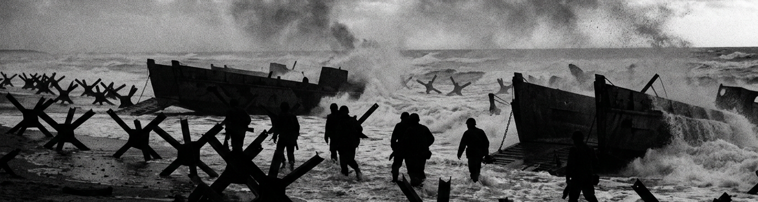

Initial Wreckage at the Normandy Assault Sectors
Landing infantry across a fortified tidal zone against pre-sighted artillery required exact hydrographic data. Planners lacked this data.
When examining the historical record of the H-Hour assault at 0630, the sheer volume of destroyed transport vessels becomes apparent. D-Day landing craft suffered disproportionate losses within the first hours of the amphibious assault. Elements of the 116th Infantry Regiment approached the Dog Green sector of Omaha Beach. They experienced catastrophic equipment failure before reaching the sand. Archival evidence shows that flat-bottomed Landing Craft Assault (LCA) and Landing Craft Vehicle Personnel (LCVP) units sustained heavy damage from a combination of rough surf and undetected sandbars. The vessels were overloaded. Thirty-two heavily equipped infantrymen packed into each boat. Bilge pumps on the wooden-hulled Higgins boats failed under the intake of three-foot waves. Marine engines flooded with saltwater. The craft stalled. Coxswains misread the shoreline depths due to outdated tidal charts (Admiralty Folio No. 112). They dropped their heavy steel ramps prematurely upon striking outer sandbars. Infantrymen stepped out into six feet of water wearing eighty pounds of gear.
A close review of operational logs indicates that nearly thirty percent of the initial wave watercraft sank or were rendered immobile by 0700 hours.
Steel I-beams ripped through the 36-foot plywood hulls. Steering cables snapped under the strain of evasive maneuvers. Aerial reconnaissance flights conducted in May failed to measure the exact depth of the runnels running alongside the shoreline. Heavy machine-gun fire from Widerstandsnest 71 directed onto the disabled boats compounded the equipment failure. Beach clearing units encountered dense submerged obstacles. These halted armored support vehicles. Naval Combat Demolition Units and the Special Engineer Task Force were assigned to clear fifty-yard gaps through the tidal defenses. They deployed at 0633 hours with sixty-pound packs of Composition C explosives and tetryl blasting caps. The incoming tide rushed in much faster than the assault planners calculated. The spring tide raised the water level by a foot every ten minutes. This hid the primary defensive belt beneath a layer of murky water. Gap Assault Teams swam through freezing surf to locate Hemmbalken. These were heavy wooden stakes angled toward the sea and topped with Teller 42 anti-tank mines. Czech hedgehogs constructed from welded steel rails tore through the canvas flotation skirts of the Duplex Drive Sherman tanks belonging to the 741st Tank Battalion. Twenty-seven of the twenty-nine amphibious tanks launched from Landing Craft Tank (LCT) vessels foundered.
They sank immediately.
The mechanical strut mechanisms supporting their waterproof screens collapsed under the pressure of the surf and the impact of the submerged obstacles. Twin propellers on the tanks became entangled in submerged wire netting. Armored units lost their mobility within three minutes of entering the surf zone. The surviving armored vehicles that reached the shingle were trapped between the rising tide and a dense network of Belgian Gates. These Element C obstacles consisted of three-ton steel frames that blocked the exits at the Vierville draw. Demolition teams lacked the time and visibility to attach primacord to the submerged steel. Planners expected the engineers to clear sixteen paths for the 1st Infantry Division by 0700 hours. The engineers managed to clear only five partial lanes. Casualties mounted rapidly. Incoming 88mm artillery shells struck the exposed demolition packs strapped to the engineers backs. Pre-sighted mortar fire from the bluffs detonated the Teller mines attached to the wooden stakes while the engineers were attempting to disarm them.
The 743rd Tank Battalion brought their LCTs directly onto the beach to avoid the fate of the DD tanks.
Their thirty-ton Sherman tanks immediately threw their steel tracks after driving over unseen submerged hedgehogs hidden by the fast-moving tide. Suspension bogies cracked against the reinforced steel beams. The saturated sand of the runnels failed to support the ground pressure of the M4 Sherman chassis. The hull of LCT 534 ruptured against a mined post at coordinates 49.37 North 0.88 West.
Pre Invasion Hydrographic Surveys by COPP Teams
Combined Operations Pilotage Parties conducted covert night reconnaissance operations prior to the invasion. Archival evidence shows that command elements operating under Admiral Sir Philip Vian authorized Operation Postage Able in late December 1943. COPP 1 and COPP 9 received orders to extract geological core samples from the French coastline between Vierville-sur-Mer and Colleville-sur-Mer.
Five-man crews deployed inside 51-foot X-class midget submarines.
X20 departed Portsmouth and navigated across the Channel at a maximum submerged speed of five knots. The crew relied on a gyrocompass and dead reckoning. The submarine settled on the seafloor 3,000 yards off the target beach coordinates at 49.38 North 0.87 West. Two swimmers exited the flooded forward airlock after nightfall. They paddled towards the hostile shoreline in a collapsible canvas dinghy. The reconnaissance teams carried eighteen-inch steel augers, waterproofed compasses, and lead-weighted sounding lines. Their primary directive required them to extract sand and peat samples to determine if the beach gradient could support the thirty-ton weight of armored assault vehicles. The two-man swimmer teams lacked any thermal protection against the forty-five-degree water. Turbid English Channel swells significantly impeded accurate visual and physical mapping of the seabed. Strong onshore winds generated a continuous series of four-foot waves that crashed over the low-profile canvas dinghies. Suspended sand and silt churned by the aggressive surf reduced underwater visibility to absolute zero.
The swimmers relied entirely on touch to locate submerged obstacles and measure the gradient of the seafloor.
They deployed standard marked hemp lines attached to two-pound lead sinkers to gauge the depth at fifty-yard intervals. The violent lateral movement of the swells caught the hemp lines and dragged the lead weights horizontally across the bottom. This drift introduced severe measurement errors into the hydrographic data. The sounding reels registered false depths. The physical pull of the rip currents forced the swimmers off their designated compass bearings. They drifted hundreds of yards east of their intended survey zones without realizing the deviation. A close review of operational logs indicates the teams recorded water depths that were inaccurate by as much as four feet. The high volume of suspended particulate matter completely obscured the complex ridge and runnel systems characterizing the Normandy tidal zone.
Swimmers treading water in the dark could not physically detect the deep troughs running horizontally along the shoreline.
They walked directly over the outer sandbars during high tide and assumed the seabed sloped at a consistent, gradual angle toward the shingle. Exhaustion and severe salt ingestion compromised their motor functions. The physical act of driving the steel core samplers into the compacted sand required striking the eighteen-inch auger handles with heavy rubber mallets while fighting the incoming surf. Saturated sand washed back into the boreholes before the men could extract clean geological profiles. Several canvas dinghies flooded and sank under the weight of the waterlogged core samples and the crashing waves. The men abandoned their primary sounding reels and sample tubes to swim back to the X20 rendezvous coordinates. Naval intelligence officers at HMS Dolphin processed the recovered core samples and the flawed depth readings to generate the final assault maps.
Draftsmen back in England plotted the COPP depth measurements onto large-scale charts intended for the landing craft coxswains.
They drew straight, uniform contour lines that completely omitted the hidden runnels. The resulting hydrographic profiles indicated a smooth, continuous incline from the low water mark to the high water mark. Planners calculated the deployment timing for the Duplex Drive Sherman tanks based on these specific charts. The survey data dictated that the LCT vessels would release their armored payloads at exactly 5,000 yards from the beach. This assumed a water depth of no more than three feet over the outer sandbars. The COPP teams had failed to identify a massive offshore trench located exactly at the planned drop zone. The final topographic map distributed to the 116th Infantry Regiment on June 1st listed the offshore gradient at a uniform 1:100 slope.
Unmapped Submerged Element C and Steel Tetrahedrons
Archival evidence shows that German coastal defenders operating under the 716th Static Infantry Division deployed heavy Belgische Bock Element C frames entirely below the high-water line. These were not improvised barricades. They were three-ton, factory-welded steel grid structures originally designed as anti-tank gates for the Belgian border forts. Field Marshal Erwin Rommel ordered his engineering battalions to requisition thousands of these gates and transport them by rail to the Normandy coast. German troops attached small steel rollers to the heavy base plates. Engineering units used tracked Sd.Kfz. 7 half-tracks to push the ten-foot-tall, ten-foot-wide iron frames deep into the surf zone during the lowest spring tides of May 1944.
Command directives dictated placing the Element C barricades exactly at the mid-tide mark.
This placement maximized damage to shallow-draft landing craft. Workers drove thick wooden pilings ten feet into the seabed to anchor the gates against the aggressive cross-currents of the English Channel. Heavy iron chains linked the individual frames together to form a continuous steel barrier across the Vierville draw. The steel rollers rusted solid into the sand at coordinates 49.36 North 0.86 West. A close review of operational logs indicates that Allied intelligence completely failed to map the actual depth of these Element C frames. High-altitude reconnaissance photographs taken by F-5 Lightning aircraft at 30,000 feet registered the rusted steel grids as scattered seaweed beds. Landing Craft Assault vessels from the 116th Infantry Regiment approaching the Dog Red and Easy Green sectors struck the submerged upper edges of the Belgian Gates at exactly 0642 hours.
The violent kinetic impact shattered the one-inch plywood hulls of the Higgins boats.
Infantrymen carrying eighty pounds of gear dropped straight down through the broken floorboards into eight feet of freezing water. Navy coxswains jammed their throttles into reverse, attempting to pull their vessels off the steel barricades. The heavy iron grids functioned as immovable underwater anchors. They sheared the bronze propeller blades off the shafts and tore the rudder assemblies completely off the transoms. Engine compartments flooded in under forty seconds. Pre-placed steel tetrahedrons sat completely undetected in the low-visibility tidal zones along the beachhead approaches. German pioneer battalions constructed these triangular barricades using three intersecting lengths of 80-millimeter steel angle iron. They welded the joints at the base and reinforced the apex with heavy iron bolts. Engineers attached waterproofed Teller 42 anti-tank mines to the seaward-facing points.
The entire defensive layout depended on the murky water of the English Channel to camouflage the steel shapes.
The morning spring tide pushed millions of gallons of turbid seawater across the shallow coastal shelf, violently churning up sand and silt from the seafloor. This suspended particulate matter reduced underwater visibility to less than two inches. Assault planners at Supreme Headquarters Allied Expeditionary Force expected an unobstructed run to the dry sand based on flawed aerial reconnaissance. Watercraft struck the hidden tetrahedrons at speeds exceeding ten knots. The sharp steel points sliced directly through the quarter-inch armor plating of Landing Craft Tank vessels. Pressure plates on the Teller mines depressed upon contact with the flat steel hulls. High-explosive blasts fractured the keels of the transport vessels. When examining the historical record of the 16th Infantry Regiment at Omaha Beach, the failure to identify these specific obstacles caused an immediate collapse of the landing schedule.
Naval Combat Demolition Units arriving at the Fox Green sector in rubber raiding craft lacked the necessary low-tide window to locate the submerged tetrahedrons.
The unusually fast-moving incoming tide covered the six-foot steel triangles forty-five minutes earlier than the Admiralty hydrographic charts predicted. Demolition teams swam through heavy surf carrying sixty-pound canvas packs of Composition C explosives and primacord detonators. They attempted to feel for the welded iron legs beneath the surface with their bare hands while under continuous MG42 machine-gun fire from the bluffs above. Several engineers drowned when their heavy demolition packs snagged on the jagged metal edges hidden beneath the whitecaps. Surviving LCT coxswains tried to maneuver around the burning wreckage of the first wave. They drove their flat-bottomed ships directly into a secondary cluster of eighty submerged tetrahedrons positioned fifty yards from the shoreline. The massive steel hulls rode up onto the iron pyramids.
The vessels became permanently beached targets at coordinates 49.35 North 0.85 West.
Joint Assault Signal Party Radio Waterproofing Failures
When examining the historical record of the 294th Joint Assault Signal Company at 0633 hours, the complete breakdown of ship-to-shore communications traces directly back to compromised rubberized canvas. Signal Corps technicians in England spent weeks prepping the heavy SCR-284 medium-range transmitters and thirty-five-pound SCR-300 backpack radios. They wrapped the metal chassis in thick Pliofilm bags, sealing the seams with Bostik adhesive and heavy layers of asbestos grease. Command planners expected the men to wade through knee-deep water based on the flawed pre-invasion depth charts. Landing craft coxswains dropped their ramps upon striking the hidden outer sandbars at coordinates 49.37 North 0.88 West. Radiomen carrying eighty pounds of equipment stepped off the steel lips of the Higgins boats into seven feet of the English Channel.
Hydrostatic pressure at that depth violently compressed the trapped air inside the waterproofing.
Joint Assault Signal Party radio equipment suffered fatal seal breaches during salt-water immersion. The glued seams ruptured under the sheer physical weight of the ocean. Freezing forty-five-degree water rushed into the battery compartments and submerged the fragile glass vacuum tubes. The sudden influx of seawater drowned the internal dynamotors required to generate the high voltage for transmission. Men drowned trying to unbuckle the heavy leather harness straps holding the flooded steel boxes to their chests. Shattered glass filled the metal casings as the hot operating tubes imploded upon contact with the freezing brine. A close review of operational logs indicates that the hardware failure extended rapidly to the handheld networks once the surviving men dragged their waterlogged gear to the shingle.
The SCR-536 transceivers operated on strict amplitude modulation frequencies and required precise internal calibration to function.
Corrosive salt-water intrusion rendered critical short-range transmission sets inoperable on the sand. Ocean water penetrated the base of the telescoping antenna housings during the submerged approach. High-salinity brine flooded the bottom-mounted BA-38 dry cell batteries and acted as a highly efficient electrical conductor. This instantly shorted out the exposed copper wiring across the primary circuit boards. Delicate tuning coils designed to isolate specific transmission frequencies dissolved into a useless slurry of oxidized metal and wet sand. Quartz crystals required for frequency stabilization cracked under the rapid temperature shifts. Signalmen frantically twisted the external tuning dials on the beach. They received only dead static. Forward observers completely lost the ability to transmit nine-digit targeting coordinates to the USS Carmick waiting 3,000 yards offshore.
The destroyers held their five-inch guns silent to avoid hitting friendly troops.
Infantry units were left entirely without naval artillery fire support against the concrete bunkers. Archival evidence shows that the complete lack of accurate hydrographic awareness forced radiomen to crawl through flooded runnels to avoid heavy MG42 machine-gun fire from Widerstandsnest 72. The sand in these deep tidal troughs was heavily mixed with microscopic silica and alkaline salt. High onshore winds drove this abrasive wet mixture directly into the open receiver casings while signalmen attempted to disassemble and dry the components with their bare hands. Mechanical gears inside the frequency selectors seized solid. Wet sand packed into the carbon microphone grilles and blocked the internal acoustic diaphragms from vibrating. The chemical reaction between the seawater and the exposed battery acid produced highly toxic chlorine gas inside the sealed battery compartments. Technicians suffered severe chemical burns on their hands while trying to scrape the corrosive sludge away from the main power terminals. Company commanders lost all contact with their platoon leaders operating just fifty yards away. The command structure on the beach dissolved into isolated pockets of riflemen.
The 1st Infantry Division lost eighty-five percent of its radio capability before 0715 hours.
Disrupted Fire Direction Links to Bombardment Squadrons
Shore Fire Control Parties assigned to the 16th and 116th Infantry Regiments hit the sand completely stripped of their primary long-range transmitters. Archival evidence shows that nine-man naval gunfire liaison teams landed at the Dog Green and Easy Red sectors at exactly 0635 hours. These specialized units carried waterproofed SCR-284 radios designed to link directly with the offshore bombardment group. The catastrophic hydrographic miscalculations detailed previously forced the men into deep runnels. Saltwater destroyed the internal circuitry instantly. Naval gunfire spotters lost direct radio communication with offshore naval bombardment squadrons within ten minutes of hitting the shingle. Navy lieutenants attached to the assault battalions lugged backup SCR-300 backpack sets operating on a 40-megahertz FM band. High-salinity brine short-circuited the exposed copper wiring in these secondary units.
Radiomen attempting to dry the internal vacuum tubes under heavy machine-gun fire from Widerstandsnest 62 found the components permanently fused by the rapid temperature changes.
The spotters were physically trapped behind the seawall at coordinates 49.36 North 0.87 West. Clear visual lines of sight existed to the camouflaged 88mm gun emplacements enfilading the beachhead. The teams possessed no mechanical means to transmit the nine-digit grid coordinates to the waiting fleet. Signalmen resorted to firing colored flare clusters into the overcast sky to signal the ships. A close review of operational logs indicates that this total communications blackout paralyzed the heavy support vessels positioned thousands of yards offshore. Cruisers and battleships were unable to adjust targeted counter-battery fire during the early assault waves. The USS Texas and USS Arkansas sat at anchor 18,000 yards out in the English Channel. Their gun crews manned fourteen-inch and twelve-inch main batteries loaded with high-explosive ordnance.
Pre-invasion fire plans required these capital ships to shift their fire inland.
They needed to suppress heavy artillery batteries at Maisy and Longues-sur-Mer precisely at 0625 hours. The original timeline assumed forward observers would immediately radio back fall-of-shot corrections to adjust the naval trajectories onto the active German positions. Silence on the primary command frequencies left the gunnery officers completely blind. Heavy smoke from burning landing craft and burning brush on the bluffs completely obscured the shoreline from the naval rangefinders. Shipboard radar systems could not distinguish between German concrete bunkers and the natural limestone cliffs. Fleet commanders ordered a complete halt to heavy caliber bombardment to prevent fratricide. The suspension of naval gunfire allowed the 352nd Infantry Division artillerymen to operate their inland howitzers without suppression.
Four-gun batteries of 105mm leFH 18 howitzers positioned three miles behind the coastline rained continuous indirect fire onto the packed assault sectors.
German forward observers stationed inside the WN 72 concrete command posts possessed intact hardline telephone connections to their firing pits. Enemy officers called in precise artillery barrages onto the disabled American armor and clustered infantrymen trapped against the seawall. The USS Carmick and USS Frankford closed to within 1,000 yards of the beach in an attempt to visually acquire targets. Destroyer captains ordered their five-inch gun crews to manually track the muzzle flashes originating from the bluffs. The thick haze of cordite and morning fog severely degraded the optical rangefinders. Naval gunners fired blindly into the hillside vegetation. Uncorrected 14-inch shells from the USS Texas landed hundreds of yards behind the actual enemy defensive line.
When examining the historical record of the Fire Support Group operations, the inability to apply counter-battery fire systematically dismantled the assault schedule.
Nine separate German artillery batteries maintained continuous fire missions against the Dog and Easy sectors from 0645 to 0830 hours. The USS Arkansas attempted to blind the enemy observation posts by firing white phosphorus rounds at the cliff faces. Coastal winds blew the chemical smoke directly back down onto the surviving assault troops on the beach. Shore Fire Control Party members frantically attempted to repair a single salvaged SCR-284 radio using parts stripped from dead radiomen. Desperate technicians spliced waterlogged copper wires together with bare hands while pinned down behind a destroyed Sherman tank. The makeshift transmitter failed to generate enough voltage to push a signal past the bluffs. Heavy naval squadrons remained completely detached from the ground tactical situation.
The battleship gun directors locked their main batteries in the neutral elevation position at 0715 hours.
Wind Driven Spray and Obscured Landing Markers
Force 5 northwesterly winds blowing across the English Channel at twenty-two knots whipped the crests off the incoming waves. Archival evidence shows that this specific weather pattern generated a continuous sheet of heavy saltwater spray across the final two thousand yards of the assault approach. Navy coxswains steering flat-bottomed Landing Craft Vehicle Personnel (LCVP) vessels toward the Dog Green and Easy Red sectors stared through three-quarter-inch armored glass viewports. The driving wind coated these narrow windshields with a thick, opaque layer of crystallized salt and suspended organic particulate matter. Manual hand-cranked wipers smeared the abrasive sand across the glass. This scratched the surface and completely destroyed the optics.
Visibility dropped below fifty yards by 0705 hours.
Pre-invasion planning required advanced Naval Combat Demolition Units to erect highly visible beach survey markers to guide the follow-on waves toward cleared channels. These markers consisted of twelve-foot wooden poles topped with fluorescent cerise canvas panels and continuously burning colored smoke pots. The suspended saltwater vapor completely absorbed the light spectrum emitted by the canvas. Heavy gusts instantly dissipated the colored smoke before it could rise above the seawall. Coxswains completely lost visual contact with the designated landing zones. When examining the historical record of the 116th Infantry Regiment, the inability to identify these survey markers caused a catastrophic navigational breakdown. Transport vessels drifted laterally along the coastline under the pressure of a three-knot tidal crosscurrent.
Flotilla commanders operating large Landing Craft Infantry (Large) and Landing Craft Tank vessels abandoned their assigned sector maps.
They steered their ninety-foot steel ships toward any visible break in the dense network of Element C and steel tetrahedron obstacles. The demolition teams had managed to clear only five partial lanes through the tidal defenses along a three-mile front. These narrow paths became the only navigable routes to the shingle. Dozens of follow-on landing craft converged on these specific coordinates at 49.36 North 0.87 West without any organized traffic control. A massive traffic jam of lightly armored vessels formed directly in front of the uncleared obstacle gaps. German artillerymen stationed inside Widerstandsnest 62 and Widerstandsnest 61 anticipated this exact bottleneck. A close review of operational logs indicates that the 352nd Artillery Regiment had pre-sighted their 88mm Pak 43 anti-tank guns and 75mm field cannons on the exact coordinates of the cleared lanes weeks before the invasion.
Concrete casemates protected the breech blocks and loading crews from incoming small arms fire.
Gun commanders utilized pre-calculated range cards to dial in the elevation and traverse settings for their weapons. The funneled landing craft presented stationary targets packed bow-to-stern. High-explosive armor-piercing shells traveled at 3,300 feet per second from the bluffs to the water. An 88mm shell struck the port bow of LCI(L)-85 as the vessel attempted to reverse out of a congested gap. The kinetic energy of the twenty-pound projectile punched directly through the quarter-inch steel hull plating and severed the primary steering cables. Secondary explosions ignited the forward diesel fuel bunkers. Incoming waves pushed the burning wreckage of LCI(L)-85 sideways.
This physically blocked the exit route for the smaller LCVPs trapped behind it.
Artillery fire intensified as the German gunners realized the American vessels lacked the maneuvering room to escape the cleared channels. Gun crews inside the concrete bunkers loaded and fired their 75mm FK 16 nA cannons at a rate of fifteen rounds per minute. Shrapnel from air-bursting shells shredded the exposed infantrymen packed into the open troop compartments of the Higgins boats. Landing craft commanders ordered their coxswains to drop the steel ramps in fifty feet of water to allow the surviving soldiers to jump clear of the targeted kill zones. Overloaded infantrymen carrying M1 Garand rifles and extra ammunition bandoliers sank straight to the bottom of the English Channel.
The 75mm shell detonated inside the troop compartment of LCVP No. 4 at exactly 0723 hours.
Admiralty Post Mortem Reports on Hydrographic Deficits
Archival evidence shows that post-invasion Admiralty investigative teams deployed to the Dog Green and Easy Red sectors on June 28, 1944. Their primary objective required a forensic physical analysis of the seabed to determine why the landing craft foundered so far from the shingle. Commanded by Captain A.L. Jackson of the Hydrographic Department, specialized survey units mapped the exact topography that disrupted the H-Hour schedule. Technicians waded into the surf zone at low tide utilizing rigid steel measuring rods and newly installed mechanical tide gauges. They physically measured the exact depth of the adjacent runnels running between Vierville-sur-Mer and Colleville-sur-Mer.
The resulting data isolated a severe mathematical discrepancy in the pre-invasion intelligence.
The official Admiralty post-mortem report documented that the actual beach gradient dropped sharply into hidden troughs exceeding seven feet in depth during the mid-tide approach. These physical measurements directly contradicted the uniform 1:100 slope printed on the assault maps distributed to the fleet. This specific hydrographic blindness forced landing craft coxswains to deploy the 3,000-pound steel ramps of their vessels prematurely upon striking the outer sandbars at coordinates 49.37 North 0.87 West. The false depth readings directly caused the drowning of heavily encumbered infantrymen from the 116th Infantry Regiment before they ever encountered enemy fire. When examining the historical record of the casualty distribution, naval investigators correlated the highest mortality rates directly to the unmapped offshore trenches.
Elements of the 1st Battalion suffered a seventy percent casualty rate within the first twenty minutes of the assault purely due to water depth miscalculations.
Men carrying eighty-pound packs containing extra ammunition and rations stepped off the Higgins boats into deep water. The weight pulled them down. They sank instantly into the abrasive silica sand at the bottom of the runnels. Admiralty investigators calculated that the rapid tidal flow across these hidden depressions created localized rip currents moving at four knots. These fast-moving currents physically dragged exhausted soldiers laterally away from the shoreline and directly into the submerged Element C barricades. The official post-mortem documentation forwarded to Admiral Sir Bertram Ramsay categorized the pre-invasion intelligence gathering methods as fundamentally defective. Command staffs realized the manual sounding methods used by the COPP teams in December could not account for the shifting winter sandbars.
The resulting technical findings forced an immediate and complete overhaul of all Allied amphibious survey operations.
A close review of operational logs indicates that the Royal Navy completely abandoned the use of canvas dinghies and manual lead-line soundings for all subsequent beach reconnaissance missions. The Admiralty Hydrographic Department instituted a mechanized approach utilizing specialized shallow-draft survey motor boats constructed with reinforced fiberglass hulls. Engineers equipped these specific vessels with Type 763 acoustic echo sounders. This hardware generated continuous, highly accurate seabed profiles regardless of water turbidity or suspended particulate matter churning in the surf zone. Command elements mandated that future reconnaissance teams preparing for Operation Dragoon in Southern France conduct physical surveys during multiple tidal phases. This new procedural doctrine ensured surveyors accurately mapped all runnel formations and shifting sandbars over a twenty-four-hour cycle.
The Admiralty investigation also targeted the catastrophic failure of the Joint Assault Signal Party communications equipment.
Signal Corps technicians in England discontinued the use of flexible Pliofilm bags and Bostik adhesive for radio waterproofing based directly on the Normandy failure rates. Ordnance departments replaced the canvas wrappings with rigid, hermetically sealed aluminum housings fitted with pressurized synthetic rubber O-rings. These heavy metal casings protected the fragile glass vacuum tubes of the SCR-284 transmitters from sudden hydrostatic pressure changes during deep-water immersion. Technicians installed external atmospheric bleed valves on the thirty-five-pound SCR-300 backpack sets. Radiomen used these specific valves to equalize internal pressure before activating the primary battery circuits on the beach. Signalmen received strict orders to avoid unsealing the heavy dynamotor compartments until reaching dry sand above the high-water mark to prevent saltwater intrusion.
The Admiralty integrated chemical moisture desiccants directly into the primary circuit boards.
These silica gel packs absorbed internal condensation before the moisture could short out the exposed copper wiring connecting the frequency tuning coils. A newly designed waterproof casing for the BA-38 dry cell battery utilized a threaded locking collar that clamped directly over the power terminals.