
22:47 ZULU, 14 OCTOBER 2004. Grid 07°34'N 05°49'W. Deep inside Marahoué National Park, a French Foreign Legion reconnaissance patrol registered the headlights of a logging truck. It was operating far outside sanctioned concession boundaries. This single data point was a tactical indicator of a wider strategic problem. The First Ivorian Civil War, which had fractured the nation since September 19, 2002, was not a simple fight for political control. It was a conflict fueled by the systematic plunder of the state’s natural resources. The initial trigger had been a failed coup against President Laurent Gbagbo, an event that rapidly escalated as rebel soldiers seized key northern cities like Bouaké and Korhogo. The country was cleaved along a north-south axis. A government-held south, containing the economic capital of Abidjan, faced a rebel-controlled north. The rebel coalition, eventually consolidated as the Forces Nouvelles de Côte d'Ivoire (FNCI), was led by figures like Guillaume Soro. They opposed the national army, the Forces Armées Nationales de Côte d'Ivoire (FANCI), and an array of pro-government militias.
A tense and violent stalemate set in. International forces deployed to manage the crisis. France, the former colonial power, initiated Opération Licorne, sending thousands of troops to stabilize the front line and protect foreign nationals. They were joined by peacekeepers from the Economic Community of West African States (ECOWAS), a mission later absorbed into the United Nations Operation in Côte d'Ivoire (UNOCI). A key component of their mandate was the establishment of a Zone of Confidence, a demilitarized buffer strip snaking across the country's center. UNOCI operational logs from the period reveal the difficulty of this task. The zone, often dense forest and remote rural tracks, was porous and frequently violated by armed groups from both sides. The international contingent, over 10,000 personnel at its peak, policed a fragile peace where ceasefires were made and broken with regularity, as seen in the government’s 2004 bombing of Bouaké that killed nine French peacekeepers and sparked severe anti-French riots in Abidjan.
The FNCI, landlocked and unrecognized, required a robust funding stream to procure arms and administer the northern half of the country. Historical records show they achieved this by creating a parallel war economy based on illicit resource flows. The FNCI seized control of regional agricultural production, smuggling cocoa and cotton across the borders into Mali and Burkina Faso. This denied tax revenue to Gbagbo’s government. The rebels also took over artisanal diamond mining areas around Séguéla and Tortiya. A UN embargo on Ivorian diamond exports was imposed in 2005, but these conflict diamonds continued to be smuggled out, providing millions in revenue. This economic engine was supplemented by an illegal timber trade, with uncontrolled logging in rebel-held national parks generating hard currency from the sale of tropical hardwoods. This system of resource exploitation was the logistical foundation that sustained the FNCI's multi-year insurgency.
While French and UNOCI forces were the public face of the intervention, a discreet American presence operated in the background. Declassified summaries from the period show this was not a large deployment. It involved small, rotating teams of US special operations personnel, primarily from units under the Joint Special Operations Task Force-Trans Sahara (JSOTF-TS). These elements, designated as Special Operations Forces Liaison Elements (SOFLE), were not engaged in direct combat. Their mission was to embed within the intelligence and operations directorates of the UN and French commands, and with select, vetted FANCI units. Their function was advisory. They provided technical expertise on fusing intelligence, surveillance, and reconnaissance (ISR) data to build a comprehensive operational picture. Archival evidence shows these teams were instrumental in establishing intelligence-sharing protocols. Data from disparate sources, including French drone feeds, UN human intelligence, and American signals intelligence, could be collated, analyzed, and disseminated coherently.
This advisory footprint was backed by a significant intelligence-gathering apparatus. The primary goal, as outlined in summaries of the Trans-Sahara Counterterrorism Partnership (TSCTP), was to monitor and disrupt the flow of illicit resources funding regional insurgencies. For Côte d'Ivoire, this meant focusing on the Forces Nouvelles' war economy. The American contribution was predominantly in signals and imagery intelligence. Records indicate US intelligence agencies, likely the DIA and NSA, re-tasked satellite assets for regular sweeps of northern Côte d'Ivoire. This provided high-resolution imagery of new logging roads being cut into the forests of the Mont Péko and Marahoué National Parks. Analysts could track the movement of vehicle convoys. This imagery was correlated with signals intelligence that intercepted unencrypted radio and satellite phone communications between rebel commanders, logging crews, and smugglers. A detailed picture of the illicit timber trade’s command-and-control structure began to form.
Raw intelligence was rarely shared in its original form. It was first processed through US Africa Command (AFRICOM) analysis centers in Europe. There, it was stripped of any indicators that would reveal sources and methods. The resulting sanitized intelligence reports, often providing just grid coordinates for suspicious activity or highlighting a specific route as a high-probability smuggling corridor, were then passed to UNOCI and Opération Licorne intelligence officers. This allowed international forces to act on the information, perhaps by increasing patrols along a specific track, without compromising the sensitive capabilities that generated the lead. The focus remained fixed on the economic lifelines of the rebellion. Analysts tracked the entire chain, from the felling of trees in rebel territory to their transport across the porous northern borders.
By late 2004, a consensus formed within the JSOTF-TS intelligence directorate. Satellite observation and signals intelligence intercepts were strategically valuable, but insufficient for tactical action against the Forces Nouvelles’ timber operations. A new asset was needed, one capable of persistent, low-altitude surveillance. A formal request resulted in the deployment of specialized ISR aircraft, likely drawn from Air Force Special Operations Command (AFSOC) inventory and staged from allied airfields outside Côte d'Ivoire. The operational objective was clear. Provide real-time, actionable intelligence on smuggling activities to French and UNOCI ground forces. This required an airborne platform that could loiter for extended periods over the remote forest tracks of the Marahoué and Mont Péko National Parks.
The solution arrived in the form of modified C-130 Hercules variants. Operational logs from this period point to the use of either the MC-130H Combat Talon II or the sensor-laden AC-130U Spooky gunship. The C-130 airframe was ideal, known for its long range, substantial loiter time, and ability to operate from austere runways. The special operations variants were transformed into powerful surveillance platforms. The MC-130H’s distinctive nose cone housed the AN/APQ-170 multi-mode radar. This system combined forward-looking radar with advanced terrain-following and terrain-avoidance capabilities, allowing crews to fly missions at extremely low altitudes, even in adverse weather. This radar suite was paired with a chin-mounted sensor turret containing high-resolution electro-optical and forward-looking infrared (FLIR) cameras. The AC-130U featured a similar, if not more advanced, sensor package designed to find and identify targets for its side-firing cannons. This suite included multispectral television sensors and high-definition infrared systems, allowing operators to identify targets from a standoff distance.
The entire effort was built around night observation. The FNCI’s logging and smuggling convoys moved almost exclusively after dark. The core of the new ISR mission was to own the night. Flying high-altitude, circular orbit patterns known as pylon turns, the C-130 crews could use their thermal imagers to scan vast swaths of the jungle. Against the cool backdrop of the nighttime terrain, the heat signature from a truck's engine block would appear as a distinct, white-hot shape. AFSOC sensor operators could detect and track these vehicles with exceptional precision. The initial concept of operations was to use this real-time intelligence to vector French or UN ground patrols for an interception. The density of the jungle and the limited number of available ground units created a significant time lag. A truck identified by an orbiting gunship could be gone long before a ground team could be dispatched. This operational gap created an intense focus on the interdiction potential of the aircraft themselves. The AC-130U, with its integrated cannons and 105mm howitzer, possessed an obvious and immediate solution for stopping a vehicle. This presented commanders with a tempting tactical shortcut, shifting the mission profile from pure intelligence gathering toward armed reconnaissance.
The goal was economic strangulation. Operational logs from the Trans-Sahara Counterterrorism Partnership show the primary American objective was to sever the financial arteries of the Forces Nouvelles. The effort was not about targeting individual rebel units for kinetic strikes. It was about building a complete pattern-of-life picture of their entire economic enterprise. ISR operations were designed to map every stage of the process, from the felling of trees in protected national parks to their final cross-border transit into Mali and Burkina Faso. This was a data-driven campaign waged across the electromagnetic spectrum and from orbital platforms, feeding a complex analytical process shared between US advisors, French Opération Licorne forces, and UNOCI intelligence cells.
Surveillance operations spanned the breadth of the Ivorian interior. Archival evidence shows a particular focus on the Marahoué and Mont Péko National Parks. These protected areas, now lawless zones under FNCI control, had become epicenters of the illegal logging trade. Initial surveillance relied heavily on satellite imagery intelligence (IMINT). Analysts at AFRICOM intelligence centers in Europe would task satellites for regular passes, scrutinizing the resulting images for the signs of new logging activity: fresh tracks spiderwebbing into untouched forest, the expansion of clear-cut zones, and the establishment of clandestine loading sites. This strategic-level observation was effective for identifying long-term degradation but lacked the tactical immediacy needed for interdiction. The jungle canopy often obscured vehicle movement, and the nine-hour to twelve-hour revisit rate of many imaging satellites created significant gaps in coverage. The FNCI moved their valuable hardwood convoys almost exclusively under the cover of darkness.
This intelligence gap drove the generation of highly specific analytical products focused on what reports designated as solid wood products. These were not raw data dumps but fused intelligence reports, combining satellite imagery with signals intelligence that captured fragments of radio and satellite phone traffic between FNCI commanders and smugglers. Historical records indicate these reports provided a granular understanding of the smuggling cycle. They identified the specific types of trucks used, estimated cargo capacity, and logged departure times from known logging sites. The reports meticulously charted the primary and secondary routes used by the convoys, highlighting choke-points, river crossings, and the locations of informal rebel checkpoints. This information, stripped of any indicators that could compromise sources, was then formatted into actionable intelligence packages for UNOCI and French patrols. A typical report might identify a three-truck convoy of MAN logging trucks departing a holding area near grid 07°34'N 05°49'W, assessing a high probability of it transiting north along a specific dirt track towards the border after 22:00 ZULU. These reports transformed the abstract concept of an illicit economy into a concrete set of targets, vehicles, and routes that ground forces could, in theory, intercept.
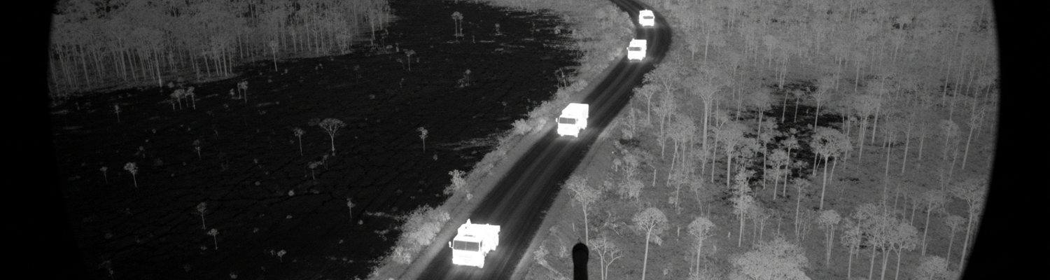
The error began in the sterile confines of an AC-130U Spooky gunship, orbiting at 12,000 feet in the humid night air above the Zone of Confidence. After-action reports from the mission on November 6, 2004, detail how the aircraft’s sensor operators, part of an AFSOC detachment, were scanning the labyrinth of dirt tracks west of the Marahoué National Park. On their monitors, the world below was a landscape of cool, dark greens and blacks, rendered by the high-definition AN/AAQ-26 infrared detecting set. Shortly after 01:30 ZULU, they spotted what they were looking for. A series of bright, white-hot signatures moving in a disciplined convoy. Five heavy vehicles, their engines and exhaust manifolds glowing intensely against the cold jungle floor, were navigating a route known for FNCI smuggling.
This was a classic target profile.
The misidentification was not a single failure but a cascade of compounded assumptions. The thermal imagers, while powerful, could be deceived by atmospheric moisture and distance, blurring the precise shapes of the vehicles. From their slant angle over two miles away, the sensor operators identified the vehicles as MAN trucks, a model frequently used by both legitimate logging companies and rebel logistics units. The critical error occurred in interpreting the cargo. The trucks were laden with massive, freshly felled tree trunks, their residual heat and density creating a solid, uniform signature on the thermal display. The operators, trained to look for military equipment and conditioned by weeks of searching for illicit weapons convoys, misread these long, cylindrical shapes. They saw what they expected to see. Not timber. The logs were logged as large-caliber pipe, bridge sections, or pre-fabricated concrete, all materials consistent with the construction of heavy fortifications. The convoy was not a commercial enterprise; it was assessed as a military engineering convoy. In reality, it was a civilian timber operation, run by a local Ivorian businessman out of a small sawmill near Bouaflé, operating without formal sanction in the chaotic wartime economy.
The raw data, now tainted by this initial misinterpretation, was transmitted via a secure satellite link to the JSOTF-TS intelligence fusion cell. Here, analysts were under constant pressure to generate actionable intelligence. They received the gunship’s report: five trucks carrying suspected fortification materials, moving north. This single report was immediately cross-referenced with other, unrelated intelligence fragments. A review of the archival intelligence summaries for that week reveals a critical piece of context: a vague and uncorroborated signals intelligence intercept from three days prior had mentioned a Forces Nouvelles commander requesting materials to reinforce a command bunker near the rebel stronghold of Vavoua. This previous intercept, filed as low-confidence, was now seen in a new light. The analysts connected the two data points. They believed the AC-130U had found the very convoy mentioned in the radio traffic. The civilian logging trucks were now definitively re-classified in the shared intelligence picture as a critical rebel supply convoy, tasked with building up defensive positions.
The process of creating the flawed intelligence report was rapid. The JSOTF-TS analyst responsible for the sector drafted a formal report, elevating the convoy from a target of interest to a high-priority interdiction target. The report confidently stated that a five-vehicle FNCI convoy was transporting materials for the construction of fortified bunkers. The assessment included the vehicle types, their last known location and heading, and a fused analysis that linked the visual evidence from the gunship to the prior signals intercept. Confidence in the assessment was marked as high. This formal intelligence product was then disseminated to the French Opération Licorne tactical operations center, the command responsible for coordinating ground-based interdiction missions within that sector. The report did not contain the raw thermal imagery or any of the ambiguity from the initial spot report. It presented only the final, confident, and dangerously incorrect conclusion. The recommendation was clear. The convoy represented a significant military threat and its neutralization was recommended.
The critical engagement sequence began with the formal handoff of the intelligence product from the JSOTF-TS fusion cell to the French Opération Licorne tactical operations center. Declassified operational summaries show this was not a casual tip; it was a high-confidence targeting package. The report, now stripped of its speculative origins, authoritatively identified a five-truck Forces Nouvelles convoy at a specific grid reference, detailing its contents as military engineering materials and its mission as the fortification of rebel positions near Vavoua. For the French command, this was actionable intelligence of the highest order. The a priori credibility of the American technical intelligence apparatus meant the report was taken at face value.
The tactical problem fell to a company of the 2nd Foreign Infantry Regiment (2e REI), a unit with extensive experience in African operational theaters. The company commander, examining the intelligence, faced a classic time-space dilemma. The convoy was moving. The window for interception was closing. The terrain, a dense tapestry of forest and secondary tracks west of the Marahoué National Park, offered the convoy multiple potential routes north. A direct assault by vehicle was deemed too slow. The French VAB armored personnel carriers would be loud and restricted to the more established tracks, likely alerting the convoy. The decision was made to execute a textbook ambush. Based on the convoy's last known heading and speed, French planners identified the most probable intersection for an intercept: a narrow laterite track at grid reference 07°58'N 06°02'W, where the path was constricted by a dense stand of ironwood trees and a shallow ravine.
A platoon of Legionnaires was dispatched. They moved on foot and under strict radio silence to the designated ambush site. Their standard operating procedure for such an action indicates they would have established a kill zone approximately 200 meters long, siting their machine guns and APILAS rocket launchers to cover the entire length of the target area. The plan was simple. The lead truck would be disabled by a command-detonated mine or rocket, blocking the route of escape. The rear vehicle would be targeted simultaneously, trapping the convoy. The remaining Legionnaires, positioned on the high ground overlooking the track, would then engage the trapped vehicles and any dismounting personnel. They reached the ambush site and set their positions in the pre-dawn darkness. A professional and well-rehearsed military action set in motion by a fundamentally flawed piece of information.
The engagement began precisely at 04:12 ZULU. The lead truck of the civilian logging convoy, a battered Berliet GBC 8KT, rumbled into the designated kill zone. The Legionnaires initiated the ambush exactly as planned. The lead truck was struck by an APILAS rocket, the 112mm high-explosive anti-tank warhead detonating against the engine block and sending the vehicle slewing into the trees. Within seconds, the trailing truck was also hit. The intervening three vehicles, their drivers shocked and disoriented, were raked with machine-gun fire. The entire event was over in less than two minutes. It was only as the sun rose, and the Legionnaires moved in to secure the site, that the nature of the intelligence failure became apparent. Instead of FNCI rebels and military supplies, they found the bodies of civilian Ivorian truck drivers and logs of tropical hardwood. The fortification materials were nothing more than valuable timber, illegally harvested but of no direct military significance.
The discovery by the French Foreign Legion patrol sent an immediate shockwave through the Opération Licorne command structure. The local French commander immediately imposed a communications blackout and ordered the site secured, recognizing the potential for a localized error to ignite a nationwide conflagration. The decision was made to frame the ambush as a legitimate, if mistaken, counter-rebel action. In the hyper-charged atmosphere of Abidjan, where President Laurent Gbagbo’s government was already engaged in a media campaign accusing French and UN forces of aiding the northern rebels, the incident became a powerful weapon. Before French commanders could control the narrative, Ivorian government-controlled media began broadcasting reports of French forces murdering innocent Ivorian workers. This single tactical event was deliberately amplified, providing the final pretext for Gbagbo’s pre-planned Operation Dignity, a major government offensive against the rebel-held north. On November 6, 2004, the Ivorian Air Force launched air strikes against rebel positions in Bouaké. During this offensive, two Ivorian Sukhoi Su-25 attack jets, piloted by foreign mercenaries, bombed a French military base, killing nine French soldiers and one American civilian aid worker. The flawed intelligence and subsequent ambush had cascaded into a direct, violent confrontation between the Ivorian state and a major Western power.
The diplomatic fallout from the Bouaké bombing was immediate and severe. French President Jacques Chirac ordered a retaliatory strike. French military actions were not proportional but annihilatory; French forces attacked the Yamoussoukro airport and other airfields, destroying the two Su-25 jets responsible for the attack along with the rest of the small Ivorian Air Force, including several Mi-24 helicopter gunships. While a militarily decisive action to prevent further air attacks, the destruction of a sovereign nation’s entire air force by its former colonial power sent catastrophic diplomatic signals across Africa. The move was widely seen as neocolonial gunboat diplomacy, undermining the legitimacy of the French peacekeeping mission. For the United States, whose intelligence had set the entire chain of events in motion, it was a public relations disaster. The US was forced to publicly support its French allies while privately managing the fallout with African Union and ECOWAS partners who saw the French action as an unacceptable escalation. The United Nations Security Council was forced into an emergency session. It unanimously passed Resolution 1572 on November 15, 2004, condemning the Ivorian air strikes but also imposing a full arms embargo on the country, a move designed to constrain all parties after the French retaliation had already altered the military balance.
The rapid escalation and heavy-handed French response shattered Côte d'Ivoire’s fragile peace process. The destruction of the Ivorian Air Force was portrayed on state-controlled Ivorian television as an act of war. Pro-Gbagbo militias, most notably the Young Patriots, were mobilized and directed to attack French interests. For three days, Abidjan and other southern cities descended into chaos as violent mobs looted and burned French businesses, schools, and residences. French armored vehicles and troops had to fight their way through the streets of Abidjan, firing on rioters to secure key infrastructure and evacuate thousands of terrified European nationals. The fighting between French forces and Ivorian mobs and military elements left dozens, if not hundreds, of Ivorians dead. This explosion of violence rendered the Linas-Marcoussis peace accords effectively dead. The Zone of Confidence, once a fragile buffer, became a hard front line. Both the government and the FNCI rebels used the crisis as proof of the other’s treachery, digging in for a prolonged conflict that would require a much larger and more forceful international intervention years later.
A review of intelligence gathering protocols from the November 2004 incident reveals a systemic failure rooted in technological limitations and human confirmation bias. The AC-130U Spooky gunship’s AN/AAQ-26 infrared detecting set performed exactly to its technical specifications. It detected heat. On the sensor operator’s display, the large, dense logs, still retaining some of the day’s solar heat, presented a solid and uniformly warm thermal signature. This signature was ambiguous. The AFSOC crew, whose training was heavily weighted toward counter-terrorism operations in the Middle East, was conditioned to search for military hardware. In that context, long, cylindrical objects in a convoy could plausibly be interpreted as artillery pieces or engineering materials. The initial, uncertain field assessment was not a technical malfunction but a cognitive leap, an attempt to fit an ambiguous image into a familiar threat template. This initial misinterpretation was then fed into a JSOTF-TS fusion cell where the second stage of the failure occurred. Analysts, under pressure to produce actionable intelligence, linked the gunship’s report to a three-day-old, low-confidence signals intercept. This single, tenuous link was treated as corroboration.
The event became a defining case study on the lessons of ISR interpretation in the complex environments that characterized post-Cold War conflicts. The primary lesson was that in irregular warfare, the line between military and civilian activity is often non-existent. Illicit economies, like the Ivorian timber trade, use the same heavy equipment and convoy tactics as a logistics corps, creating significant potential for misidentification. The incident demonstrated that advanced thermal imagers show only heat signatures, not intent. Without deep contextual understanding of the local operational environment, sensor operators are interpreting in a vacuum. The intelligence community learned that technological overmatch does not eliminate ambiguity. It can create a false sense of certainty, where a crisp thermal image is trusted more than it should be. The failure in Côte d'Ivoire underscored the absolute requirement for multi-source intelligence fusion before any kinetic action. A single technical intelligence source, no matter how sophisticated, was proven to be an insufficient basis for a lethal decision.
This mistaken ambush had a direct and lasting impact on future air force advisory and interdiction doctrines. AFSOC and the wider USAF integrated this failure into training curricula, particularly for sensor operators and intelligence analysts supporting special operations. New training modules were developed focusing specifically on identifying dual-use equipment and signatures common in irregular warfare scenarios, moving beyond a narrow focus on conventional military hardware. The incident heavily influenced the codification of targeting procedures, reinforcing the principle that dynamic targeting is a process, not just a mission type. A key doctrinal shift was the strengthened emphasis on the role of a certified Joint Terminal Attack Controller (JTAC) or a designated ground commander in the kill chain. The authority to clear fires was reinforced as belonging to the entity on the ground with direct observation or the best contextual understanding of the target area, not the airborne sensor operator. The concept of target custody was refined, ensuring that a target identified by one asset must be positively confirmed through other means before engagement. This was a direct response to the analytical failure of linking the AC-130U’s visual data to an unrelated SIGINT report. Air Force doctrine evolved to treat the human in the loop as a point of critical judgment, not simply a final switch-flipper, mandating a procedural skepticism toward any single stream of intelligence in unconventional conflicts.